Search This Blog

17 May 2018

thumbnail

EVENT — Gexcel and HERON at GEO Business Show 2018

HERON® AC-1, the innovative Wearable Mobile Mapping System from Gexcel, is having a significant success worldwide on innovative BIM-check projects. Several customers are using the HERON® change detection feature to highlight differences between the reality and the BIM model: everything in real time.

Real-time and effective scan to BIM quality check services on huge sites, such as airports, industrial plants, and construction yards are now possible!


HERON® can survey complex environments without any external positioning system and is capable to highlight in real-time possible geometrical changes between different surveying sessions. Moreover, HERON® works as a localization system using either a former survey or a CAD model as reference frame.

Thanks to these unique features, HERON® has been adopted by international institutions and large companies involved in the nuclear power plant and advanced industrial projects.


>> Visit Us on Stand L15 at GEO Business (22-23 May, London) <<


10 May 2018

thumbnail

SUCCESS CASE — UNDERGROUND ARCHAEOLOGICAL SURVEY

STUDY OF THE HYPOGEUM SITE AND PRODUCTION OF VIRTUAL REALITY Hellenistic Necropolis of Neapolis, Napoli (ITALY)

PDF versione italiana

PROJECT DESCRIPTION

KEYWORDS: Virtual Reality | JRC 3D Reconstructor | 3D Laser Scanner | Photogrammetry | Archeology

«The Hellenistic Necropolis of Naples presents chamber tombs from the Hellenistic period (V-III century BC) characterized by monumental façades dug into the tuff. The site is crossed by the canal bridges of the imposing Augustus aqueduct of Serino» (Carlo Leggieri, Celanapoli).
Since the site is only partially open, there is a project in progress to be able to benefit from the good in a "digital" way through the production of an Immersive Virtual Tour.
The survey has developed for hundreds of meters in depth, acquiring data through laser scanners integrated with the photogrammetric survey of the individual chamber tombs and part of the aqueduct. The site develops from 0 to about -35 meters underground.
The processing of point clouds, generated with different techniques and instruments, was very effective thanks to JRC 3D Reconstructor. The advanced tools for data management and filtering allowed us to perform the first data processing, producing point clouds and 3D models for a deeper and fine study of the Hypogeum site. The further data processing allowed to extract orthophotos, plants and elevations at millimetre precision, as well as to create an immersive virtual reality application.

ACAS3D - JRC 3D Reconstructor - chamber tombs point cloud orthographic view in reflectance - hypogeum site of Naples Necropoli (Italy)
Fig.1_Chamber tombs: point cloud orthographic view in reflectance
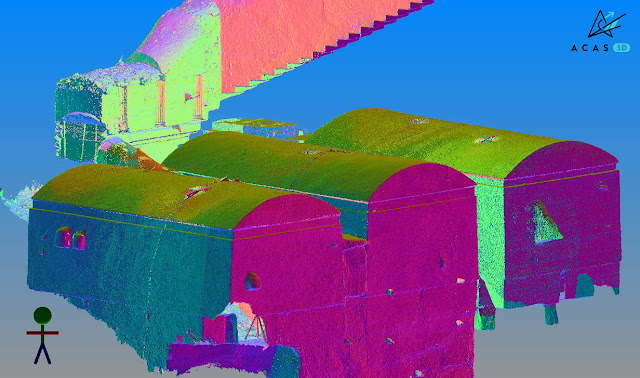
ACAS3D - JRC 3D Reconstructor - chamber tombs point cloud model inclination value - hypogeum site of Naples Necropoli (Italy)
Fig.2_Chamber tombs: 3D point cloud model with inclination value
ACAS3D - Photogrammetric station and fresco orthophoto - hypogeum site of Naples Necropoli (Italy)
Fig.3-4_Photogrammetric station and fresco orthophoto


« The technology of Gexcel software, developed by experts in the field, is the basis of truly versatile products able to guarantee a very satisfactory processing experience »

Federico Capriuoli
Acas3D | Civil Engineer


NEEDS AND GOALS
  • Laser scanner and photogrammetric survey for the study of the Hypogeum site.
  • Creation of a topographical reference network. 
  • Millimetre precision of the elaborates.
  • Production of an immersive virtual tour.


RESULTS

  • 2D models
  • 3D models
  • High-resolution orthophotos
  • Plants, elevations, and sections
  • Immersive virtual tour


ACAS3D - Orthographic view of the external façades - hypogeum site of Naples Necropoli (Italy)
Fig.5_Orthographic view of the external façades
ACAS3D - 3D point cloud model - hypogeum site of Naples Necropoli (Italy)
Fig.6_3D point cloud model


JRC 3D RECONSTRUCTOR MAIN BENEFITS
  • Effectiveness of processing functions
  • Management of data from different types of surveying hardware
  • Alignment and filtering tools for point clouds


TECHNICAL DETAILS (*project still in progress)
  • SURVEYING SYSTEM: Terrestrial laser scanner - Total station - Super High-Res reflex cameras (Nikon D850)
  • PROCESSING SOFTWARE: JRC 3D Reconstructor Heritage-Architectural - Photogrammetric software - Graphic engines (Unity/Unreal)
  • SURVEYING DATA*: 6.600 photograms - 460 laser scans
  • PROCESSING TIME*: 1 month

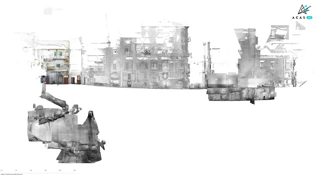
    ACAS3D - Trasversal section - hypogeum site of Naples Necropoli (Italy)
    Fig.7_Trasversal section
    20 October 2018 Grosseto > Don't miss the official project presentation


    ABOUT

    Acas3D Srs | www.acas3d.com
    The ACAS3D \ Hera Srl company, based in Grosseto (Italy), deals with laser scanner/photogrammetric surveys for the historical buildings and cultural heritage field.

    19 Apr 2018

    thumbnail

    ELISIR project: eco-seismic building regeneration 4.0

    Gexcel will provide its own technologies in 3D mapping, fast 3D digitalization, and BIM model update within the ELISIR project. These technologies are essential to drastically reduce costs and times of surveying activities and to assess in real-time the as-built conditions of a building.

    ELISIR stands for Energy, Life Styled & Seismic Innovation for Regenerated Buildings and it aims at exploiting the potential of digitization in order to create a very personalized product-service to be offered on the market of the existing building heritage focused on seismic improvement and energy efficiency in a "smart living" way, developing a real "Built in Italy". The research project has been launched last November with a research call funded by the Lombardy Region and will end in May 2019.

    gexcel-heron-elisir-progetto

    Gexcel participates in the project, along with other important partners, using the HERON technology for the rapid survey of buildings, for the as-built data acquisition in the form of a point cloud, and will further develop the product adding the possibility of collecting camera data. Schneider will contribute by developing appropriate sensors for energy analysis, a platform for collecting, storing and processing data and validating them. Valsir will undertake the development of hydraulic connections leveraged by sensors, to monitor all the water consumption of the various users. H&D will craft appropriate financial products to provide "the business model and a brand capable of spreading and introducing innovation in the supply chain" with possible "consequences on foreign markets that will be investigated together with the partners involved". Delta Phoenix will fine-tune the energy seismic plaster. The development of smart windows will be taken care by Italserramenti, which will experiment products with a high degree of automation and intelligence, able to adapt to users' needs and independently manage environmental comfort.

    The concept of the project was born at the DICATAM headquarters in the University of Brescia, on the initiative of Angelo Ciribini, one of the leading experts in Building Information Modeling (BIM) and digitization in construction. The second university involved is the Milan Polytechnic, with the Abc department - Architecture, Engineering and the built environment, and in particular with the operating units "Building envelope engineering group" and "Sustainable building process management group". Find more...

    6 Apr 2018

    thumbnail

    SUCCESS CASE — CONSERVATION, RECOVERY AND RESTORATION OF HISTORICAL BUILDINGS

    The ancient complex "Convent and Prison of S. Domenico buildings" San Gimignano, Siena (Italy)

    PDF versione italiana


    PROJECT DESCRIPTION

    KEYWORDS: Classification Mapping | JRC 3D Reconstructor | 3D Laser Scanner | Heritage | Architectural

    Assignment carried out in 2016 and 2017 for the underground part, commissioned by the Public Authority of San Gimignano (Siena) to the "RTP Borromini" group, a multidisciplinary professional team composed of specialists in architecture, engineering, restoration, and archaeology. The STUDIO ASSOCIATO PERIGEO was involved in the topographic and laser scanners survey. The complicated geometries detected with the 3D laser scanner, together with the accurate topographic survey, were then used for all the subsequent phases of detail analysis and output of a unique georeferenced system. Thanks to the data processing software JRC 3D Reconstructor, it was possible to collect and share 3D outputs from laser scanner scans and an in-depth evaluation of underground constructions of historical and anthropological interest.

    studio associato perigeo, jrc 3d reconstructor, complex "convent & prison of S. Domenico buildings" S.Gimignano, Siena (IT)
    Fig.1_Surveying activity
    studio associato perigeo, jrc 3d reconstructor, complex "convent & prison of S. Domenico buildings" S.Gimignano, Siena (IT)
    Fig.2_3D coloured point cloud model: a global view of the complex with caves


    « Thanks to the Gexcel software, I could complete an important laser scanner survey with high accuracy and quality, very demanding for its features and dimension »

    Roberto Pierini
    STUDIO ASSOCIATO PERIGEO | Senior Surveyor


    NEEDS AND GOALS

    • An integrated geometric dataset for multidisciplinary technical activity aimed at reconstructing the cognitive framework.
    • Essential geometric data for subsequent conservation, recovery, and enhancement of the historical compendium. 
    • Accurate 3D laser scanner survey of façades, cloister, chapel and underground cavities.
    • Topographic support.


    RESULTS

    • Detailed technical table
    • Plans, sections, elevations, high-resolution orthophotos and photo plans
    • 3D point cloud model
    • 3D model flythrough movies
    • Mines and tunnels 3D metric survey

    studio associato perigeo, jrc 3d reconstructor, complex "convent & prison of S. Domenico buildings" S.Gimignano, Siena (IT)
    Fig.3_Hypogeal tunnels with altimetric colouring
    studio associato perigeo, jrc 3d reconstructor, complex "convent & prison of S. Domenico buildings" S.Gimignano, Siena (IT)
    Fig.4_Vertical section and orthographic view of the cave interior
    studio associato perigeo, jrc 3d reconstructor, complex "convent & prison of S. Domenico buildings" S.Gimignano, Siena (IT)
    Fig.5_3D coloured model | Global view and internal detail


    JRC 3D RECONSTRUCTOR MAIN BENEFITS

    • Easy management of a big dataset
    • Millimetre precision of the results
    • Compatibility of different laser scanners
    • Fast third-party software connection


    TECHNICAL DETAILS

    • SURVEYING SYSTEM: Laser scanner Faro Focus3D X130 - Total station Leica TS06
    • SURVEYING AREA: Area: 8.700 m² approximately - Prospects: 15.000 m² approximately
    • SURVEYING TIME: Topographic and laser scanner: 6 days (2 operators)
    • PROCESSING SOFTWARE: JRC 3D Reconstructor - PointR3
    • PROCESSING TIME: Laser models: 30 days (1 operator)


    studio associato perigeo, jrc 3d reconstructor, complex "convent & prison of S. Domenico buildings" S.Gimignano, Siena (IT)
    Fig.6_Final delivery | Orthophoto inserted into the 3D point cloud

    studio associato perigeo, jrc 3d reconstructor, complex "convent & prison of S. Domenico buildings" S.Gimignano, Siena (IT)
    Fig.7_Final delivery | 3D coloured models


    ABOUT

    STUDIO ASSOCIATO PERIGEO | www.studioperigeo.it
    The STUDIO ASSOCIATO PERIGEO, by Roberto Pierini and Valentina Tinti, features more than 30 years of experience in topographic, architectural, building and inventory surveys; for public associations and administrations as for individuals, businesses, or professionals in the fields of renovation and design, where it is important to create functional synergies to provide adequate metric datasets necessary for consistent and sound tasks performance.


    27 Mar 2018

    thumbnail

    EVENT — Gexcel and CSMT at the First China Global Experts Summit (CGES)

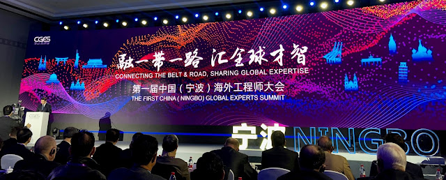
    20th March 2018, China — The first China (Ningbo) Global Experts Summit (CGES).


    CGES 2018


    The Global Experts Summit is a worldwide meeting focused on the world's cutting-edge technology and China's industrial demands, creating a platform where global talents and technologies seek cooperation and achieve win-win results.

    The CSMT of Brescia (Italy) attended the summit as a successful example of Italian technology transfer center and Gexcel was invited as one of the representative expert companies located at the CSMT technology center.


    During the event, Mr. Matteo Sgrenzaroli (R&D Project Manager at Gexcel) focused his presentation by showing the benefits of LiDAR technology, the new engineering solutions, and the market outer reach.


    A total of 239 high-tech projects from a variety of industries (aerospace, integrated circuits, new materials, etc.) sought cooperation and financial support through roadshows and matchmaking events at the summit.

    Find more about the event


    6 Feb 2018

    thumbnail

    PRESS RELEASE — GEXCEL and 3DFLOW: a stronger partnership to integrate LiDAR and Photogrammetric technologies

    6th February, 2018, Italy — Gexcel is proud to announce the latest strengthening of the partnership with 3DFlow, finalized to improve the integration between their specific sectors: LiDAR and Photogrammetry.


    The task to provide to the market outstanding solutions and products capable to integrate LiDAR and Digital Photogrammetry is one of the main strategic goal of both companies, Gexcel and 3DFlow.

    The partnership between Gexcel and 3DFlow started in 2012, when an innovative software for digital Photogrammetry was commonly customized and named PixR3 to satisfy the needs of Gexcel's customers.

    In these years the competence and the diffusion of Gexcel's products in the global LiDAR market are dramatically grown and the products like JRC 3D Reconstructor® (software for LiDAR data management) and HERON® (SLAM based mapping wearable system) are became estimated and well known products worldwide.

    On the other hand, also the worldwide presence and high competence of 3DFlow products and services in the digital photogrammetric field are exponentially grown. For this reason both partners have commonly decided to be more focused on their main technology competence, not forgetting the strategic importance of the integration between LiDAR and Digital Photogrammetry products.
       
    The strengthen partnership will allow Gexcel to full benefit of the 3DFlow technology in a more integrated and cross way. Gexcel portfolio will be now enriched with all the 3DF Zephyr® software solutions, perfectly integrated with JRC 3D Reconstructor® LiDAR software, to provide ever more complete solutions to users and final clients.


    Follow Gexcel on gexcel.it/software/3df-zephyr to learn more on the software integration and 3DF Zephyr® software.


    About Gexcel

    Gexcel has a rich history spanning more than 10 years of proven fully featured LiDAR and imagery analysis software like the well-known JRC 3D Reconstructor®. Gexcel’s software are compatible with the LiDAR sensors of the main laser scanner manufactures such as Faro, Geomax, Riegl, Stonex, Surestar, Teledyne-Optech, Topcon, Trimble, Velodyne and Z+F. Gexcel is currently present on the market with innovative surveying systems (HERON® and OPMMS®) and it is involved, with several partners, in various projects for the development of innovative solutions based on laser scanner, SLAM and digital photogrammetry. Gexcel was established in 2007 from the academic know-how of the University of Brescia and the applied research achievements of the European Joint Research Centre (JRC), located in Ispra (Italy).

    About 3DFlow
    3Dflow is a completely private held consulting company and software house operating in the field of Computer Vision and Image Processing. It was established in 2011 as a spin-off of the University of Verona and in 2012 it became a spin-off of the University of Udine. 3Dflow is a dynamic, innovative company committed to providing cutting-edge solutions and software components involving Photogrammetry, 3D modeling of reality, 3D processing and 3D visual effects. Its customers ranges from small local industries to worldwide leading entertainment companies.

    --------------


    Published on:

    - https://www.geoconnexion.com/news/a-partnership-to-integrate-lidar-and-photogrammetric-technologies
    - http://www.amerisurv.com/content/view/16560/
    - http://www.lidarmag.com/content/view/12650/

    11 Sept 2017

    thumbnail

    CASE STUDY — Fast 3D mapping and "as built - as designed" analysis of a Le Corbusier style building in Italy


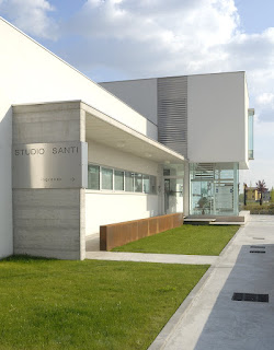
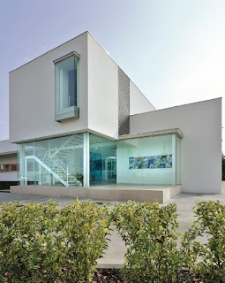
    A pleasant Le Corbusier style building has been surveyed with HERON to analyze the structure realization and study how its shape could be inserted in the urban context.


    Location Studio Santi Castel Goffredo, ItalyLocation Studio Santi Castel Goffredo, Italy

    • Location: Studio di Architettura e Ingegneria "Arnaldo Santi" of Castel Goffredo (North Italy)
    • Application: by Topotek Srl
    • Industry: Construction
    • Surveying system: HERON AC-1 Color


    HERON has been able to impressively respond to the two main specific customer's needs:
    1. Check the correspondences between the existing BIM project (as designed) and the geometric results of the as-built construction process.
    2. Carry on fast surveying of large areas, getting results almost in real-time in order to quickly pass to a pre-projects analysis and operate in construction sites affected by fast changes.


    IN DETAIL...

    The entire survey of the indoor/outdoor parts of the site took about 10 minutes.

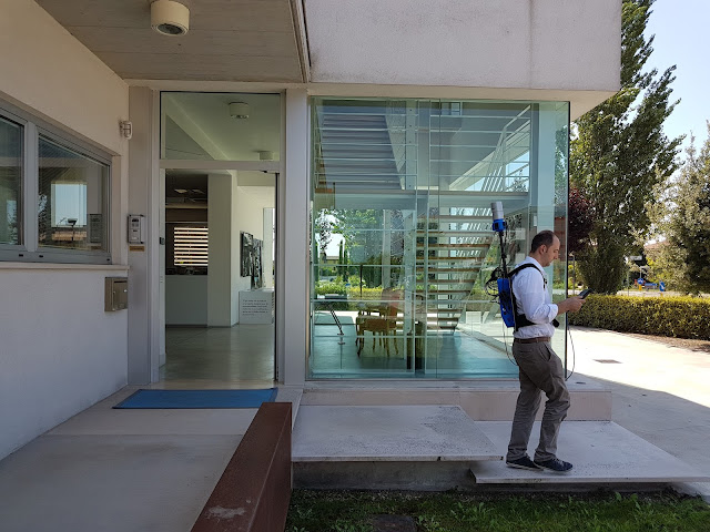
    HERON survey of Studio Santi building
    The surveying process at Studio Santi site by using HERON AC-1 mobile surveying system

    After only 20 minutes of elaboration, a scaled plan view of the site was available and ready to be visualized in a CAD environment. The point cloud, obtained from HERON, has been moved into JRC 3D Reconstructor software where the BIM model of the building has been compared with the HERON point cloud model.


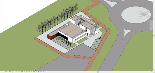
    Revit model of Studio Santi building
    The Autodesk Revit model of the building realized with a BIM approach

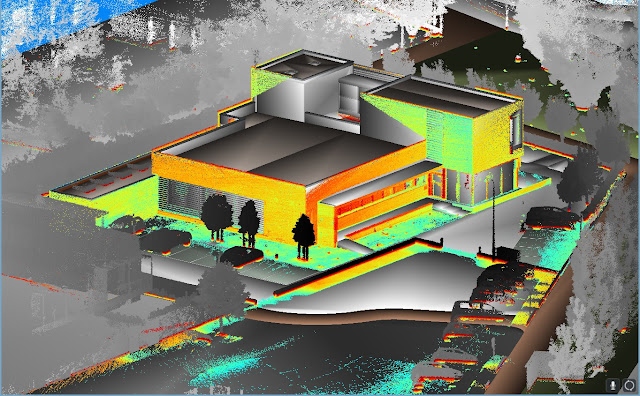
    HERON and BIM models comparison in JRC 3D Reconstructor
    The comparison between BIM model and Heron data in JRC 3D Reconstructor

    The results show the good correspondence (2-3 cm of differences measured) between the BIM model and the reality. The experience has shown the high productivity and accuracy (tested with few control points) of the HERON SLAM approach thanks to a high resolution 32 lines Velodyne rotating laser scanner and a robust patented "global optimization" approach.

    HERON Global Optimization
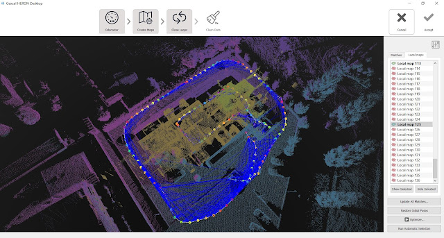
    The result of the global optimization process

    In order to insert the 3D survey of the building within a new survey of the city centre, the HERON automatic self-localization function has been used. The HERON post processed point cloud model of the building was loaded inside HERON that used it as reference model. Coming back to the site some days after the first acquisition, HERON was able to automatically recognize its position respect to the point cloud reference model and start mapping the city center. In this way, the 3D fast mapping model of the town has been easily joined to the 3D model of the building, without using targets or reference points.

    heron blue print of studio santi mantova italy
    Fast blueprint image of the 3D mapping of Castel Goffredo town

    The town survey required 3 hours, at a normal walking speed, without care of sky visibility and without requiring a local calibration. Stairs, trees, different geometries are not a problem for HERON and the 3D survey data are directly visible, in real-time, on the touch screen control unit provided with the instrument. The first result of the HERON survey is the so-called "fast blueprint image": an easy result that can be immediately imported into CAD software without any other 3D point cloud data processing.

    heron blue print of studio santi mantova italy
    Fast blueprint images of the 3D mapping of Castel Goffredo town, including the Studio Santi site


    WHAT THE BENEFITS OF HERON TECHNOLOGY?
    • HERON can strongly support the construction sites in fast "as-built / as designed" analysis, where a 2-3 cm accuracy can be acceptable.
    • The automatic geo-localization capability can introduce the innovative fast and frequent 3D models updating services, carried on by operators with basic knowledge in surveying and geolocalization.

    Thanks to Studio di Architettura e Ingegneria "Arnaldo Santi" and Topotek Srl