Search This Blog

Showing posts with label jrc 3d reconstructor. Show all posts

26 Feb 2019

thumbnail

PRESS RELEASE — NEW Reconstructor® 4.0

26th February 2019, Italy — Gexcel today announced a new JRC 3D Reconstructor® release with revolutionary changes and improvements that are going to bring interesting and powerful features on the 3D LiDAR data processing software market. 

With the coming release, the well-known software manufactured by Gexcel will change its name in Reconstructor®, a revised brand for a new agile and easily usable application. This newest release 4.0 expands on the most popular software features, providing customers with even more opportunities to get more out of their dataset, save time and build stunning deliverables.

“Since the beginning, Reconstructor® has been a unique tool for a wide range of laser scanning users. This new release is a great step forward in terms of efficiency, usability, and brilliance”, said Matteo Sgrenzaroli, Gexcel’s R&D manager. “There’s a rich basket of new features in this new release, and we can’t wait to see what users will create with it”.


These are some of the key functions added or improved in Reconstructor® 4.0:

  • NEW SOFTWARE MODULARIZATION and LAYOUT to organize the processing tools and customize the software user interface: Reconstructor® 4.0 and its new add-ons are organized in a completely new user interface that provides simple and straightforward access to the software tools.
  • NEW RENDERING ENGINE for a new powerful way to display 3D modelsReconstructor® 4.0 upgrades the 3D visualization engine providing a completely new and more efficient rendering environment for clouds and meshes, unlocking a completely different experience of 3D object visualization. A strong improvement in using the PC graphics resources will let customers handle point clouds up to 200% larger than before.
  • FASTER and MORE EFFICIENT DATA IMPORT and PROCESSING: With Reconstructor® 4.0, the time required for scan importing and filtering is dramatically reduced, saving more than twice the time required by previous releases.
  • LineUp to automatically register CAD and BIM models: LineUp®, the popular and appreciated technology for automatic scans registration, is now fully embedded in Reconstructor® 4.0 main module. The well-known automatic target-less registration tool has been improved to support CAD/BIM and mesh models. 
  • X-RAY ORTHOPHOTOS for easy measuring and drawing: Reconstructor® 4.0 offers a completely new way to extract orthophotos and blueprints enhancing the relevant geometric features of a 3D scanned object. With the innovative GoBluprint free tool, it will be extremely easy to share X-Ray orthophotos among the users' community.

Press HERE to discover the entire changelog for Reconstructor 4.0 


DISCOVER. TRY. ENJOY

RECONSTRUCTOR® 4.0
 FREE DOWNLOAD

For more information or to receive a quotation, contact us: sales@gexcel.it

12 Dec 2018

thumbnail

JRC 3D RECONSTRUCTOR SUCCESS CASE — EARTHQUAKE DEFORMATIONS CHECK

RESTORATION AND CONSERVATION INTERVENTION Temple of Belén, Cusco (PERU)

PDF versione italiana

PROJECT DESCRIPTION

KEYWORDS: Architectural | Conservation | JRC 3D Reconstructor | Laser scanner


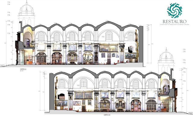
The church of Belén stands on a strongly seismic territory that from its origins has undermined the structure, rebuilt several times. After the damages caused by the earthquake of 1950, the internal consolidation of the vaults and domes was carried out, in order to avoid subsequent collapses, and only recently (for the first time!) a laser scanner survey was commissioned by the Ministry of Culture in Cusco to evaluate the actual structural conditions of the church and undertake restoration work. Thanks to this important technological step, it was immediately possible to notice some serious structural problems concerning the subsidence of the cupola. An aspect that would never have emerged with traditional measurement systems.


Restauro sac_Templo de Belén-Cusco_JRC 3D Reconstructor_Survey activities and 3d point cloud model
Fig.1_Survey activities and 3D point cloud model

NEEDS AND GOALS
  • Measure, analyze and document the phenomena of the degradation of the church useful for the restoration project.
  • Get for the first time an accurate survey to obtain a full view of the building.

« Working with highly technological tools allows great precision in a short time, which for the client translates into high quality at affordable prices. JRC 3D Reconstructor is an easy-to-use software: only one operator can do the whole job obtaining accuracy never seen before! »

Wilfredo Torres | CEO at Restauro S.A.C.

Restauro sac_Templo de Belén-Cusco_JRC 3D Reconstructor_Side elevation with high-res orthophoto
Fig.2_Side elevation with high-res orthophotos
Restauro sac_Templo de Belén-Cusco_JRC 3D Reconstructor_CAD drawings with high-res orthophoto
Fig.3_CAD drawings with high-res orthophotos

TECHNOLOGY BENEFITS
  • Rapidity of 2D and 3D data extraction.
  • Millimetre accuracy of the technical result.
  • Precision and accuracy of data.
  • Time savings in data processing and acquisition.

RESULTS

  • Detailed report of vaults deformations
  • Plans, elevations, sections 
  • High-Res orthophotos 
  • Data precision and accuracy 

TECHNICAL DETAILS 

  • SURVEYING SYSTEMS: Faro Focus3D 130x laser scanner
  • SURVEYED AREA: 3,145.50 sqm
  • SURVEYING TIME: 3 days
  • PROCESSING SOFTWARE: Reconstructor | AutoCAD
  • DATA PROCESSING TIME: 1 month

Restauro sac_Templo de Belén-Cusco_JRC 3D Reconstructor_CAD redrawing on the high-res orthophoto
Fig.4_CAD redrawing on the high-res orthophoto


ABOUT

RESTAURO S.A.C. is a Peruvian company that offers a wide range of services related to Cultural Heritage needs. Founded in October 2009, it offers solutions for management, conservation and restoration problems thanks to a national and international experience as well as a selected professional team and high-level technologies.


5 Dec 2018

thumbnail

JRC 3D RECONSTRUCTOR SUCCESS CASE — NON-INVASIVE ARCHITECTURAL DIAGNOSIS

ANALYSIS AND CAD REPORT OF AN ANCIENT STABLE Rustic Court “La Faggiola”, Piacenza (ITALY)

PDF versione italiana

PROJECT DESCRIPTION

KEYWORDS: Architectural | Conservation | JRC 3D Reconstructor | Laser scanner


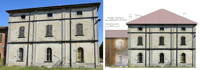
Rustic Court “La Faggiola”, Piacenza (ITALY) - Picture of the building and CAD redrawing  and high resolution colored orthophotos - by Studio Tecnico Cottini - JRC 3D Reconstructor
Fig.1_Picture of the building and CAD redrawing with high-resolution coloured orthophotos

The “Faggiola” Rustic Court is an ancient private residence (now public) dating back to the early twentieth century. Having been neglected for a long time, the client decided to check its status by relying on 3D surveying technologies, before proceeding with redevelopment works and refurbishment and restoration interventions. During the days on the field, we worked with laser scanner instruments and it was possible to detect the geometry of the entire building: from the external areas to every single room, obtaining the highest precision necessary for the graphics redrawing. The material components of the building have been of great importance: building and finishing materials, signs left over from the passage of time, have contributed to a greater understanding of the building's real conditions. The methodology used, fast and non-invasive, is suitable for completing architectural diagnoses of buildings and defining the type of interventions to be carried out, be it demolition or restoration.


NEEDS AND GOALS
  • A detailed survey of the external and internal environments of the building.
  • Graphics rendering of the exact geometry of the building (plans, sections, and elevations) and material components.
  • Future restoration and conservation interventions.

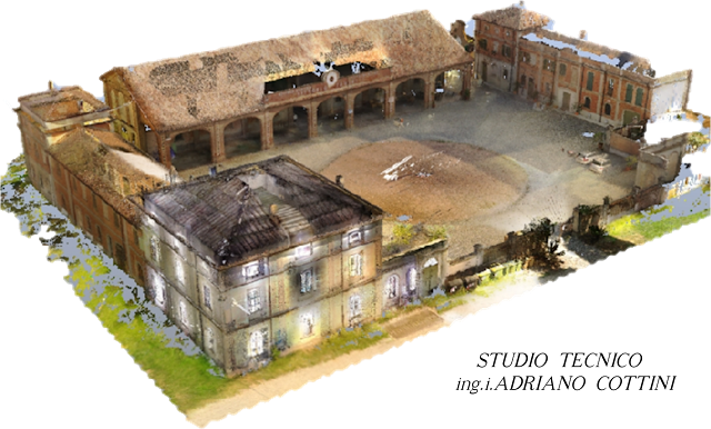
Rustic Court “La Faggiola”, Piacenza (ITALY) - Colorful 3D model - point cloud (general view) - by Studio Tecnico Cottini - JRC 3D Reconstructor
Fig.2_Colorful 3D model - point cloud (general view)

Rustic Court “La Faggiola”, Piacenza (ITALY) - CAD redrawing with high resolution colored orthophotos - by Studio Tecnico Cottini - JRC 3D Reconstructor
Fig.3_CAD redrawing with high-resolution coloured orthophotos

« Thanks to the data collected during the laser scanner survey and the use of JRC 3D Reconstructor processing software, it was possible to obtain a thorough reading of the material components of the building, through the extraction of high-resolution orthophotos, following applied to the CAD drawings. »

Elena Plebani | Architect at Studio Tecnico Cottini

RESULTS
  • Detailed technical table with high-resolution orthophotos
  • 3D point cloud model
  • 2D plans and views with millimetric precision

TECHNOLOGY BENEFITS
  • The precision of final results
  • Management of data coming from different laser scanners.
  • Quick and precise processing of data.

TECHNICAL DETAILS
  • SURVEYING SYSTEM: Terrestrial Laser Scanner | Total Station
  • SURVEYED AREA: 700 m²
  • SURVEYING TIME: 2 days
  • PROCESSING SOFTWARE: JRC 3D Reconstructor
  • DATA PROCESSING TIME: 2 weeks

« The merging between the processed point clouds and the traditional topographic polygon, inside JRC 3D Reconstructor, completes the survey in any aspect. »

Marco Salvi | Engineer at Studio Tecnico Cottini

Rustic Court “La Faggiola”, Piacenza (ITALY) - Colorful 3D model - point cloud (partial view) - by Studio Tecnico Cottini - JRC 3D Reconstructor
Fig.4_Colorful 3D model - point cloud (partial view)


ABOUT

Studio tecnico ing.i. Adriano Cottini
The Cottini engineering studio deals with topographic surveys, laser scanner surveys, data processing from point clouds, drafting of graphics drawings and planning for residential and civil construction works.


7 Aug 2018

thumbnail

JRC 3D RECONSTRUCTOR SUCCESS CASE — ARCHAEOLOGICAL MEASUREMENT

CONSERVATION AND RESTORATION Tambomachay complex, Cusco (PERU)

PDF versione italiana

PROJECT DESCRIPTION

KEYWORDS: Cultural Heritage | Archaeology | JRC 3D Reconstructor | LiDAR data

Tambomachay, Peru - Orthophoto of the entire complex - by Restauro SAC - JRC 3D Reconstructor
Fig1_Orthophoto of the masonry complex

In 2017, the CDC Ministry of Peruvian culture commissioned to Restauro S.A.C. the surveying of some Inca historical sites. The Tambomachay is one of these: near to Cusco, this site consists of a series of aqueducts, canals, and waterfalls running through the terraced rocks. It is important to know that, till not long time ago, the measurement of these ancient walls was done by very rudimentary techniques: large sheets of millimetric paper were placed on the wall to manually trace the contours of every single stone and later manually redrawn in the CAD environment. As you can imagine, this workflow is incredibly time/money expensive as it requires months (years!) of work to get results always uncertain, because of drawing errors or missing details (ledge, cavity, pictures, etc.). This the reason that brought the company to operate with a laser scanner technology to face this important work. Thanks to this method it was possible to make a complete survey in less than one working day and extract rocks contour lines measurable with millimetric precision, thanks to the JRC 3D Reconstructor post-processing software.


NEEDS AND GOALS
  • To measure, analyze and document the ancient masonry build by the Inca population.
  • To detect the exact position and verify the deterioration and/or structural failure over time.
  • To intervene with conservation works.

    Tambomachay, Peru - Picture of the site and orthophoto of the masonry - by Restauro SAC - JRC 3D Reconstructor
    Fig.2-3_Orthographic view and the picture of Tambomachay site

    Tambomachay, Peru - High Res orthophoto of the stones - by Restauro SAC - JRC 3D Reconstructor
    Fig.4_High Res orthophoto showing the detail of the stones

    « The processing speediness and accuracy allowed us to generate 2D and 3D data with a precision impossible for the traditional surveying methods. Thanks to JRC 3D Reconstructor, we daily improve the quality and productivity of our job. »
    Wilfredo Torres, Restauro S.A.C. | CEO

    To complete the documentation project and illustrate the real artefact conditions, a CAD drawing with orthophotos was provided.

    RESULTS
    • Detailed technical table with high-resolution orthophotos
    • 3D point cloud model
    • 2D plans and views with millimetric precision

    TECHNOLOGY BENEFITS
    • The speediness of 2D and 3D data extraction
    • The millimetric precision of technical results

    TECHNICAL DETAILS
    • SURVEYING SYSTEM: Faro Focus3D 130x
    • SURVEYING AREA: 2.982 m²
    • SURVEYING TIME: 4 hours
    • PROCESSING SOFTWARE: JRC 3D Reconstructor
    • PROCESSING TIME: 6 hours

      Tambomachay, Peru - CAD plans with CAD plans with photographic view - by Restauro SAC - JRC 3D Reconstructor
      Fig.5_Plan of the scanned site


      ABOUT

      RESTAURO S.A.C. is a Peruvian company that offers a wide range of services related to Cultural Heritage needs. Founded in October 2009, it offers solutions for management, conservation and restoration problems thanks to a national and international experience as well as a selected professional team and high-level technologies.

      9 Jul 2018

      thumbnail

      HERON SUCCESS CASE — UNDERGROUND MINING

      3D SCANNING OF AN OLD MINE Zhejiang Province (China)


      PROJECT DESCRIPTION

      KEYWORDS: Mining | Underground | HERON | 3D Mapping

      The surveying of an underground mine is difficult for two orders of problems: the complicated and dark tunnels environment and the underground depth where GPS or GNSS signal can't be reached.
      The Aurantech company has faced this problem in an old underground mine site, in Zhejiang and thanks to the HERON wearable mobile mapping system the procedure for data collection was not only possible but also efficient.
      After pre-processed the surveying acquisitions and filtered the noise, it has been possible to build the surface model of the tunnel, based on the required parameters, with a global accuracy of 10 cm.
      The data extraction has been made with JRC 3D Reconstructor software. First of all, the data have been aligned via the automatic registration and bundle adjustment software's functions. Then, the cross-sections have been easily generated and volume and surface areas computed on the 3D model. Finally, the 3D model was easily exported to third-party applications using one of the most common data interchange formats.


      Aurantech - The operator with HERON AC-1 during the surveying activities in the underground mine and HERON point cloud model with the path
      Fig 1. The operator with HERON AC-1 during the surveying activities in the underground mine
      Fig 2. HERON point cloud model of the underground mine with the path
      Aurantech - HERON 3D mesh model of the underground mine
      Fig 3. HERON 3D mesh model


      « What we had to do was just to set up some control points using a total station and then simply walk with HERON. Software and hardware made the work easier and supplied us with a complete solution. HERON is a reliable, simple and high-performance 3D solution »
      Sherry Wang
      AURANTECH | Commercial Manager


      NEEDS AND GOALS

      • Generate a precise map of an old tunnel where tripod laser scanners or GPS cannot be used.
      • Build a measurable 3D model of the underground mine starting from the 3D point cloud.


      RESULTS

      • 3D point cloud model
      • Depth calculation
      • Area calculation
      • Cross-sections
      • Volume calculation


        Aurantech - CAD environment: cross sections of the HERON point cloud model of the underground mine
        Fig 4. CAD environment: cross-sections of the HERON point cloud model


        HERON AC-1 MAIN BENEFITS

        • Work without GPS or GNSS sensors
        • The precision of final results
        • Management of wide and different data


        TECHNICAL DETAILS

        • SURVEYING SYSTEM: HERON AC-1 and total station
        • SURVEYING AREA: 250,000 sqm abandoned mine
        • SURVEYING TIME: 6 hours
        • PROCESSING SOFTWARE: HERON Desktop and JRC 3D Reconstructor
        • PROCESSING TIME: 18 hours


        ABOUT

        Aurantech | www.aurantech.com
        Aurantech is a high-tech company situated in Shangai (China) featured to provide complete 3D solutions; highly experienced in 3D project services from 3D data collection, 3D data processing to the 3D information management system for final customers.


        27 Jun 2018

        thumbnail

        JRC 3D RECONSTRUCTOR SUCCESS CASE — CULTURAL HERITAGE SURVEY

        ARCHITECTURAL SURVEYING OF A HISTORICAL BUILDING Dr. Sun Yat-Sen’s Memorial Hall, Guanzhou (CHN)

        PDF versione italiana

        PROJECT DESCRIPTION

        KEYWORDS: Cultural heritage | JRC 3D Reconstructor | 3D Laser Scanner | Chinese architecture


        Dr. Sun Yat-Sen’s Memorial Hall
        Dr. Sun Yat-Sen’s Memorial Hall Building


        NEEDS AND GOALS

        • Recording details and conditions of structure and decoration
        • Creation of fine 3D file of the historical building
        • Creation of fine 3D dataset including point clouds, CAD, photos, etc.
        • Providing 3D point cloud models for displaying and disseminate
        • Providing the online 3D model for promotion

        The Dr Sun Yat-Sen’sMemorial Hall is located in Guangzhou, China. It was built in 1929 in honour of Mr Sun Yat-Sen(the forerunner of the great democratic revolution in China) and designed by the famous architect Lu Yanzhi (1894-1929). The building has an octagonal structure and it is a combination of the Chinese traditional palace style and the Western modern space and structure design method. The two goals of the project were: 

        1. To conduct a comprehensive digital survey and acquisition of the 3D information of the historical building. 
        2. To create a fine 3D file with all the information on the preservation status of structure, decoration and equipment. This huge building was used for many years and is full of precarious equipment, structures, and decorative components, which caused lots of difficulties both for laser scanning activities and point cloud postprocessing.

        Dr. Sun Yat-Sen’s Memorial Hall Point cloud model
        Dr Sun Yat-Sen’s Memorial Hall Point cloud model

        « Thanks to JRC 3D Reconstructor we obtained the registration of more than 500 scans quickly and accurately. »
        Prof. Yangting
        SCUT | South China University of Technology

        Dr. Sun Yat-Sen’s Memorial Hall section
        Building section with reflectance

        The Gexcel software allowed to extract from the point cloud the building’s plans, elevations and sections, necessary to generate the CAD drawings on a 1:100 scale. With a highly collaborative group and AutoCAD integration, a final 3D database of Dr Sun Yat-Sen’s Memorial Hall was established for follow-up research, displaying and promotional activities. The work was successfully completed in 2 weeks.


        JRC 3D RECONSTRUCTOR MAIN BENEFITS

        • Generation of 3D point cloud models in a short time
        • Fast automatic registration of point cloud
        • Easy and quick key points generation: accurate sections of structure and details (structure, high-value elements, etc.)


        TECHNICAL DETAILS 

        • SURVEYING SYSTEM: FARO X130 & FARO X330 with RICOH THETA
        • SURVEYING AREA: 8.700 sqm
        • PROCESSING SOFTWARE: JRC 3D Reconstructor Heritage-Architectural | AutoCAD
        • SURVEYING TIME: 3 days
        • PROCESSING TIME*: 15 days

        RESULTS 

        • Full coloured point cloud of the whole building (inside and outside, view on multiplatform)
        • AutoCAD drawings for plans, elevations, sections in a 1:100 and 1:50 scale
        • Point cloud slice showing structural deformations and damage status

          Dr. Sun Yat-Sen’s Memorial Hall 2D technical table
          Building technical table, 2D CAD plan view


          ABOUT

          Guangzhou SIKAN Surveying &MappingTechnology Co., Ltd. | SCUT  en.scut.edu.cn/
          Technical consultant company dedicated to providing survey and supporting services for the reconstruction of historic buildings, renovation of old cities, and renovation of cultural relics with the aim to provide effective and reliable 3D data and archives for today's urban construction.

          10 May 2018

          thumbnail

          SUCCESS CASE — UNDERGROUND ARCHAEOLOGICAL SURVEY

          STUDY OF THE HYPOGEUM SITE AND PRODUCTION OF VIRTUAL REALITY Hellenistic Necropolis of Neapolis, Napoli (ITALY)

          PDF versione italiana

          PROJECT DESCRIPTION

          KEYWORDS: Virtual Reality | JRC 3D Reconstructor | 3D Laser Scanner | Photogrammetry | Archeology

          «The Hellenistic Necropolis of Naples presents chamber tombs from the Hellenistic period (V-III century BC) characterized by monumental façades dug into the tuff. The site is crossed by the canal bridges of the imposing Augustus aqueduct of Serino» (Carlo Leggieri, Celanapoli).
          Since the site is only partially open, there is a project in progress to be able to benefit from the good in a "digital" way through the production of an Immersive Virtual Tour.
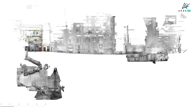
          The survey has developed for hundreds of meters in depth, acquiring data through laser scanners integrated with the photogrammetric survey of the individual chamber tombs and part of the aqueduct. The site develops from 0 to about -35 meters underground.
          The processing of point clouds, generated with different techniques and instruments, was very effective thanks to JRC 3D Reconstructor. The advanced tools for data management and filtering allowed us to perform the first data processing, producing point clouds and 3D models for a deeper and fine study of the Hypogeum site. The further data processing allowed to extract orthophotos, plants and elevations at millimetre precision, as well as to create an immersive virtual reality application.

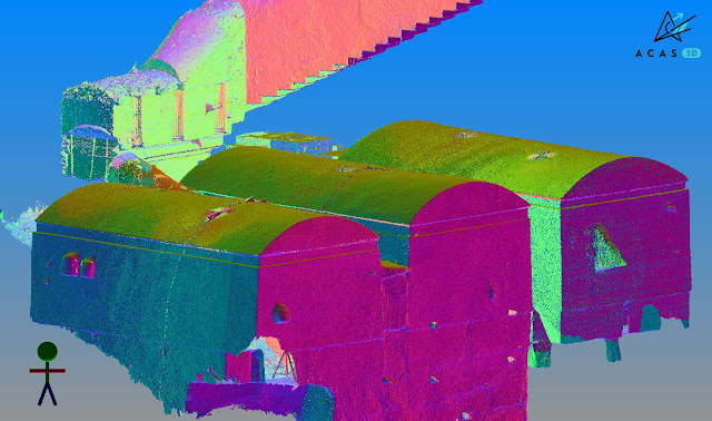
          ACAS3D - JRC 3D Reconstructor - chamber tombs point cloud orthographic view in reflectance - hypogeum site of Naples Necropoli (Italy)
          Fig.1_Chamber tombs: point cloud orthographic view in reflectance
          ACAS3D - JRC 3D Reconstructor - chamber tombs point cloud model inclination value - hypogeum site of Naples Necropoli (Italy)
          Fig.2_Chamber tombs: 3D point cloud model with inclination value
          ACAS3D - Photogrammetric station and fresco orthophoto - hypogeum site of Naples Necropoli (Italy)
          Fig.3-4_Photogrammetric station and fresco orthophoto


          « The technology of Gexcel software, developed by experts in the field, is the basis of truly versatile products able to guarantee a very satisfactory processing experience »

          Federico Capriuoli
          Acas3D | Civil Engineer


          NEEDS AND GOALS
          • Laser scanner and photogrammetric survey for the study of the Hypogeum site.
          • Creation of a topographical reference network. 
          • Millimetre precision of the elaborates.
          • Production of an immersive virtual tour.


          RESULTS

          • 2D models
          • 3D models
          • High-resolution orthophotos
          • Plants, elevations, and sections
          • Immersive virtual tour


          ACAS3D - Orthographic view of the external façades - hypogeum site of Naples Necropoli (Italy)
          Fig.5_Orthographic view of the external façades
          ACAS3D - 3D point cloud model - hypogeum site of Naples Necropoli (Italy)
          Fig.6_3D point cloud model


          JRC 3D RECONSTRUCTOR MAIN BENEFITS
          • Effectiveness of processing functions
          • Management of data from different types of surveying hardware
          • Alignment and filtering tools for point clouds


          TECHNICAL DETAILS (*project still in progress)
          • SURVEYING SYSTEM: Terrestrial laser scanner - Total station - Super High-Res reflex cameras (Nikon D850)
          • PROCESSING SOFTWARE: JRC 3D Reconstructor Heritage-Architectural - Photogrammetric software - Graphic engines (Unity/Unreal)
          • SURVEYING DATA*: 6.600 photograms - 460 laser scans
          • PROCESSING TIME*: 1 month

            ACAS3D - Trasversal section - hypogeum site of Naples Necropoli (Italy)
            Fig.7_Trasversal section
            20 October 2018 Grosseto > Don't miss the official project presentation


            ABOUT

            Acas3D Srs | www.acas3d.com
            The ACAS3D \ Hera Srl company, based in Grosseto (Italy), deals with laser scanner/photogrammetric surveys for the historical buildings and cultural heritage field.

            6 Apr 2018

            thumbnail

            SUCCESS CASE — CONSERVATION, RECOVERY AND RESTORATION OF HISTORICAL BUILDINGS

            The ancient complex "Convent and Prison of S. Domenico buildings" San Gimignano, Siena (Italy)

            PDF versione italiana


            PROJECT DESCRIPTION

            KEYWORDS: Classification Mapping | JRC 3D Reconstructor | 3D Laser Scanner | Heritage | Architectural

            Assignment carried out in 2016 and 2017 for the underground part, commissioned by the Public Authority of San Gimignano (Siena) to the "RTP Borromini" group, a multidisciplinary professional team composed of specialists in architecture, engineering, restoration, and archaeology. The STUDIO ASSOCIATO PERIGEO was involved in the topographic and laser scanners survey. The complicated geometries detected with the 3D laser scanner, together with the accurate topographic survey, were then used for all the subsequent phases of detail analysis and output of a unique georeferenced system. Thanks to the data processing software JRC 3D Reconstructor, it was possible to collect and share 3D outputs from laser scanner scans and an in-depth evaluation of underground constructions of historical and anthropological interest.

            studio associato perigeo, jrc 3d reconstructor, complex "convent & prison of S. Domenico buildings" S.Gimignano, Siena (IT)
            Fig.1_Surveying activity
            studio associato perigeo, jrc 3d reconstructor, complex "convent & prison of S. Domenico buildings" S.Gimignano, Siena (IT)
            Fig.2_3D coloured point cloud model: a global view of the complex with caves


            « Thanks to the Gexcel software, I could complete an important laser scanner survey with high accuracy and quality, very demanding for its features and dimension »

            Roberto Pierini
            STUDIO ASSOCIATO PERIGEO | Senior Surveyor


            NEEDS AND GOALS

            • An integrated geometric dataset for multidisciplinary technical activity aimed at reconstructing the cognitive framework.
            • Essential geometric data for subsequent conservation, recovery, and enhancement of the historical compendium. 
            • Accurate 3D laser scanner survey of façades, cloister, chapel and underground cavities.
            • Topographic support.


            RESULTS

            • Detailed technical table
            • Plans, sections, elevations, high-resolution orthophotos and photo plans
            • 3D point cloud model
            • 3D model flythrough movies
            • Mines and tunnels 3D metric survey

            studio associato perigeo, jrc 3d reconstructor, complex "convent & prison of S. Domenico buildings" S.Gimignano, Siena (IT)
            Fig.3_Hypogeal tunnels with altimetric colouring
            studio associato perigeo, jrc 3d reconstructor, complex "convent & prison of S. Domenico buildings" S.Gimignano, Siena (IT)
            Fig.4_Vertical section and orthographic view of the cave interior
            studio associato perigeo, jrc 3d reconstructor, complex "convent & prison of S. Domenico buildings" S.Gimignano, Siena (IT)
            Fig.5_3D coloured model | Global view and internal detail


            JRC 3D RECONSTRUCTOR MAIN BENEFITS

            • Easy management of a big dataset
            • Millimetre precision of the results
            • Compatibility of different laser scanners
            • Fast third-party software connection


            TECHNICAL DETAILS

            • SURVEYING SYSTEM: Laser scanner Faro Focus3D X130 - Total station Leica TS06
            • SURVEYING AREA: Area: 8.700 m² approximately - Prospects: 15.000 m² approximately
            • SURVEYING TIME: Topographic and laser scanner: 6 days (2 operators)
            • PROCESSING SOFTWARE: JRC 3D Reconstructor - PointR3
            • PROCESSING TIME: Laser models: 30 days (1 operator)


            studio associato perigeo, jrc 3d reconstructor, complex "convent & prison of S. Domenico buildings" S.Gimignano, Siena (IT)
            Fig.6_Final delivery | Orthophoto inserted into the 3D point cloud

            studio associato perigeo, jrc 3d reconstructor, complex "convent & prison of S. Domenico buildings" S.Gimignano, Siena (IT)
            Fig.7_Final delivery | 3D coloured models


            ABOUT

            STUDIO ASSOCIATO PERIGEO | www.studioperigeo.it
            The STUDIO ASSOCIATO PERIGEO, by Roberto Pierini and Valentina Tinti, features more than 30 years of experience in topographic, architectural, building and inventory surveys; for public associations and administrations as for individuals, businesses, or professionals in the fields of renovation and design, where it is important to create functional synergies to provide adequate metric datasets necessary for consistent and sound tasks performance.