Search This Blog

Showing posts with label presse release. Show all posts

12 Jan 2023

thumbnail

PRESS RELEASE — GEXCEL HERON 3D Mobile Mapping: Improvements in Accuracy and Usability

 Gexcel HERON software improvements


Brescia, Italy, January 12th, 2023

The recently released versions of HERON processing software(s) make HERON 3D mapping projects more accurate, effective and usable thanks to important improvements in the usage of ground control points, in the change detection workflow, and for the cloud-sharing process.
 

CONSTRAINT TOOL


Several ways to constrain and geo-reference HERON trajectories.
Ground Control Points (GCPs)
- Measuring GCPs directly in the field by using HERON and a calibrated pole or
- Identifying CGPs on the HERON point cloud.
GCPs local coordinates are automatically paired with the related global coordinates.
Point Clouds and Scans
Static scans or portions of 3D point clouds previously acquired also with different sensors (UAV, mobile scanners, mapping systems, photogrammetry) can be used as constraints as well.

Constraint procedures play a crucial role to improve the quality of the final trajectory!

CHANGE DETECTION MAPS

HERON - Change Detection Map


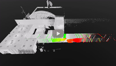
1. Use a point cloud or BIM model as a reference map.
2. Let HERON self-locate with respect to the reference.
3. Produce a survey aligned with the reference map.
4. Detect changes that occurred in the time.
5. Automatically get the change detection map for further editing.

CLOUD SHARING

Mobile mapping is dramatically speeding up the process of capturing 3D and image data. This should be matched by the speed of project delivery and online procedures.
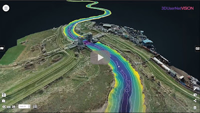


To increase Site to Sight of data efficiency, GEXCEL customers can now link up with 3DUserNet to get a special free annual subscription to the VISION platform with a direct workflow from Reconstructor to 3DUserNetVISION. This will enable users to deliver more efficiently for their customers – with the opportunity to upgrade to a full subscription at a substantial discount at any time.

For additional information: sales@gexcel.it


24 Nov 2021

thumbnail

PRESS RELEASE — GEXCEL and 3DUserNetVISION combine to offer speed and efficiency in mobile mapping

HERON & Reconstructor data sharing by 3DUserNetVISION

Brescia, Italy, November 24th, 2021

«We are glad to announce the collaboration with 3DUserNetVISION because this means we can provide our HERON and Reconstructor clients with 3D point clouds and image data sharing services for mapping projects». Giorgia Rossi, International Sales Manager of Gexcel

All data acquired with HERON and all 3D models managed with Reconstructor can now be directly uploaded to 3DUserNetVISION and shared in the cloud. And thanks to this partnership, all existing and new Gexcel customers can get the platform at a special rate.

Getting data quickly from scanner to user is more and more crucial in today's demanding world of survey, where several partners need to easily access 3D models to speed up decision-making processes. Heron and Reconstructor give you high-quality outputs quickly and accurately, VISION makes them worldwide and immediately accessible.

Uploading point clouds, meshes and images directly to 3DUserNetVISION from Reconstructor, gives immediate and secure access to project data for a team, for viewing and collaboration on deliverables. And it works on all your devices, so you have your data with you at all times.

Gexcel customers are able to obtain a 25% discount on their first full year subscription of any VISION modules and data packs. REQUIRE YOUR DISCOUNT >> CLICK HERE

12 Oct 2020

thumbnail

PRESS RELEASE — Gexcel presents HERON® MS Twin

Brescia, Italy, October 7th, 2020_Gexcel is glad to present the new HERON® MS Twin: a double Lidar sensor portable mobile mapping system, equipped with a 5k RGB panoramic camera. Thanks to its advanced hardware+software technology, the users can benefit from a very high-level performance in terms of geometric robustness of 3D models.


Key points of usability:

  • Compact capture head easily mountable on a backpack or various supports like cars, bikes, quads, etc.
  • Light rugged backpack usable both for transportation and surveying.
  • Automatic and on-demand RGB data acquisition.
  • Loop closure and initialization procedure not required.
  • Automatic self-localization on a reference model, when available.
  • Annotation collection during the walk.
  • Usable in every light conditions.
  • Hands-free surveying.
  • Real-time display of panorama images, 3D point cloud, and trajectory on the rugged Control Unit.

Key points of data processing:

  • SLAM post-processing software (HERON® Desktop) included. The automatic advanced processing tools can be also personally set up by the user.
  • New trajectory quality assessment which improves the SLAM drift effects reduction (patented algorithm).
  • Innovative very dense point cloud rendering with multiple colour layers.

HERON MS Twin color layer

  • Static scans usable as trajectory constraints (patented algorithm).
  • Innovative panorama tool to directly export images and 3D data in ReCap® (with Realview® display) and in E57 to easily go to OrbitGT, Edgewise®, FARO® Scene and Scene Webshare Cloud.
  • New “splat rendering” and “eye dome lighting" rendering effect. Features and details are emphasized and well visible.
  • GoBlueprint free tool to share the survey results with final clients or colleagues included.

HERON GoBlueprint

  • Advanced 3D point cloud data analysis software included (Recontructor®).
  • Dedicated tools to navigate 3D models.
  • Real-time change detection.

Thanks to these advanced features, HERON® MS Twin is the perfect system for surveyors who works indoors, outdoors, in underground mines, multi-level buildings, tunnels, cultural heritage sites, forensic procedures, forests, urban areas, harsh and complex areas.

HERON® MS Twin can make the user able to obtain several outputs from collected data: volume computation, excavation progress monitoring, digital archive, construction progress monitoring, floor plans generation for asset management, logistic/traffic management, dilapidation monitoring, scan to BIM, contours and profiles, 3D virtual experience, real-time change detection, as-built generation, security and safety, and much more.

* * *

New HERON MS Twin Live Demo

- watch the webinar recording -

new HERON MS Twin - Webinar
New HERON MS Twin Live demo - Recording

10 Mar 2020

thumbnail

PRESS RELEASE — Gexcel announces RECONSTRUCTOR® 4.2

Brescia, Italy, February 27th, 2020_Gexcel is glad to announce the new release of Reconstructor® that introduces some very interesting improvements for mining, tunnelling, construction, and infrastructure applications thanks to new strategic workflows designed to easily guide customers to final deliverables from the surveying data.


Reconstructor® 4.2 makes a step forward into the processing of large datasets from various 3D sensors and in particular from Mobile Mapping Systems. Reconstructor® 4.2 increases the capability to manage data from tunnels, underground and open-pit mines 3D surveys, thanks to new and improved tools that help users get the result done by a smart process.

Following, a selection of some new key functions introduced in Reconstructor® 4.2:
  • Tunnels, underground and open-pit mines: easy extraction of sequential cross-sections along tunnels axis; measurement of areas and volumes along tunnels; creation of DEM (digital elevation models) starting from 3D point clouds; straight workflow to extract isolines and contours from open-pit mine models and DEMs.
  • Terrain models, buildings and infrastructures: orthophotos can now be used to quickly and efficiently create facades' depth maps. This function can be used also by final clients thanks to the new GoBlueprint free tool. Also, the procedure to extract, display, measure, and move to CAD profiles and cross-sections is now faster and more efficient.
  • Vegetation: colour mapping for point clouds classification and to support the vegetation removal process.
For additional information and demo, click here

26 Feb 2019

thumbnail

PRESS RELEASE — NEW Reconstructor® 4.0

26th February 2019, Italy — Gexcel today announced a new JRC 3D Reconstructor® release with revolutionary changes and improvements that are going to bring interesting and powerful features on the 3D LiDAR data processing software market. 

With the coming release, the well-known software manufactured by Gexcel will change its name in Reconstructor®, a revised brand for a new agile and easily usable application. This newest release 4.0 expands on the most popular software features, providing customers with even more opportunities to get more out of their dataset, save time and build stunning deliverables.

“Since the beginning, Reconstructor® has been a unique tool for a wide range of laser scanning users. This new release is a great step forward in terms of efficiency, usability, and brilliance”, said Matteo Sgrenzaroli, Gexcel’s R&D manager. “There’s a rich basket of new features in this new release, and we can’t wait to see what users will create with it”.


These are some of the key functions added or improved in Reconstructor® 4.0:

  • NEW SOFTWARE MODULARIZATION and LAYOUT to organize the processing tools and customize the software user interface: Reconstructor® 4.0 and its new add-ons are organized in a completely new user interface that provides simple and straightforward access to the software tools.
  • NEW RENDERING ENGINE for a new powerful way to display 3D modelsReconstructor® 4.0 upgrades the 3D visualization engine providing a completely new and more efficient rendering environment for clouds and meshes, unlocking a completely different experience of 3D object visualization. A strong improvement in using the PC graphics resources will let customers handle point clouds up to 200% larger than before.
  • FASTER and MORE EFFICIENT DATA IMPORT and PROCESSING: With Reconstructor® 4.0, the time required for scan importing and filtering is dramatically reduced, saving more than twice the time required by previous releases.
  • LineUp to automatically register CAD and BIM models: LineUp®, the popular and appreciated technology for automatic scans registration, is now fully embedded in Reconstructor® 4.0 main module. The well-known automatic target-less registration tool has been improved to support CAD/BIM and mesh models. 
  • X-RAY ORTHOPHOTOS for easy measuring and drawing: Reconstructor® 4.0 offers a completely new way to extract orthophotos and blueprints enhancing the relevant geometric features of a 3D scanned object. With the innovative GoBluprint free tool, it will be extremely easy to share X-Ray orthophotos among the users' community.

Press HERE to discover the entire changelog for Reconstructor 4.0 


DISCOVER. TRY. ENJOY

RECONSTRUCTOR® 4.0
 FREE DOWNLOAD

For more information or to receive a quotation, contact us: sales@gexcel.it

11 Dec 2018

thumbnail

PRESS RELEASE — Gexcel presents the new HERON® Indoor Mobile Mapping System

11th December 2018, Italy — Thanks to the new full HD 360° panoramic camera, HERON® has become a powerful tool for geospatial data mining: to digitally document, collect and geo-reference large dataset and information inside indoor environments has never been so easy, thanks to the perfect integration with OrbitGT packages too.

Gexcel - New HERON Indoor Mobile Mapping System


Gexcel is glad to introduce the market to the innovative benefits provided by the new HERON® family:
  • Thanks to the new high-res 360° panoramic camera, HERON® has become the best choice for facility management, geospatial applications, digital 3D documentation, digital twins for remote planning and project, revamping projects of industrial plants, etc.
  • With the GoBlueprint® free tool (fast point clouds 2D visualization), HERON® users can easily share with clients, already in the field and almost in real-time, the results of the HERON® fast 3D mapping.
  • Now, point clouds coming from drones and/or static scans, as GNSS known points, can become constraints information inside the workflow of the HERON® 3D SLAM data processing.

Gexcel - GoBlueprint free tool


The HERON® family is currently composed of HERON® AC-2 and HERON® MS-2 (rugged device for underground mines or difficult environments), both available in the Color configuration. The HERON® LITE model is the best solution for customers who want to join the HERON® family with an affordable investment.


6 Feb 2018

thumbnail

PRESS RELEASE — GEXCEL and 3DFLOW: a stronger partnership to integrate LiDAR and Photogrammetric technologies

6th February, 2018, Italy — Gexcel is proud to announce the latest strengthening of the partnership with 3DFlow, finalized to improve the integration between their specific sectors: LiDAR and Photogrammetry.


The task to provide to the market outstanding solutions and products capable to integrate LiDAR and Digital Photogrammetry is one of the main strategic goal of both companies, Gexcel and 3DFlow.

The partnership between Gexcel and 3DFlow started in 2012, when an innovative software for digital Photogrammetry was commonly customized and named PixR3 to satisfy the needs of Gexcel's customers.

In these years the competence and the diffusion of Gexcel's products in the global LiDAR market are dramatically grown and the products like JRC 3D Reconstructor® (software for LiDAR data management) and HERON® (SLAM based mapping wearable system) are became estimated and well known products worldwide.

On the other hand, also the worldwide presence and high competence of 3DFlow products and services in the digital photogrammetric field are exponentially grown. For this reason both partners have commonly decided to be more focused on their main technology competence, not forgetting the strategic importance of the integration between LiDAR and Digital Photogrammetry products.
   
The strengthen partnership will allow Gexcel to full benefit of the 3DFlow technology in a more integrated and cross way. Gexcel portfolio will be now enriched with all the 3DF Zephyr® software solutions, perfectly integrated with JRC 3D Reconstructor® LiDAR software, to provide ever more complete solutions to users and final clients.


Follow Gexcel on gexcel.it/software/3df-zephyr to learn more on the software integration and 3DF Zephyr® software.


About Gexcel

Gexcel has a rich history spanning more than 10 years of proven fully featured LiDAR and imagery analysis software like the well-known JRC 3D Reconstructor®. Gexcel’s software are compatible with the LiDAR sensors of the main laser scanner manufactures such as Faro, Geomax, Riegl, Stonex, Surestar, Teledyne-Optech, Topcon, Trimble, Velodyne and Z+F. Gexcel is currently present on the market with innovative surveying systems (HERON® and OPMMS®) and it is involved, with several partners, in various projects for the development of innovative solutions based on laser scanner, SLAM and digital photogrammetry. Gexcel was established in 2007 from the academic know-how of the University of Brescia and the applied research achievements of the European Joint Research Centre (JRC), located in Ispra (Italy).

About 3DFlow
3Dflow is a completely private held consulting company and software house operating in the field of Computer Vision and Image Processing. It was established in 2011 as a spin-off of the University of Verona and in 2012 it became a spin-off of the University of Udine. 3Dflow is a dynamic, innovative company committed to providing cutting-edge solutions and software components involving Photogrammetry, 3D modeling of reality, 3D processing and 3D visual effects. Its customers ranges from small local industries to worldwide leading entertainment companies.

--------------


Published on:

- https://www.geoconnexion.com/news/a-partnership-to-integrate-lidar-and-photogrammetric-technologies
- http://www.amerisurv.com/content/view/16560/
- http://www.lidarmag.com/content/view/12650/

1 Aug 2017

thumbnail

PRESS RELEASE — New JRC 3D Reconstructor® 3.3.1

1st August, 2017, Italy — We are glad to share with you the latest improvements of JRC 3D Reconstructor 3.3.1. In this release some small bugs fixed and new features for a more flexible and smart post-processing experience implemented!

JRC 3D Reconstructor can now automatically detect reference spheres (with registration or geo-referencing of single/multiple related scans) and also generate spherical 360° panorama images from RGB camera centered on a rotating 3D scanner head. See the full list of improvements


JRC 3D Reconstructor 3.3.1 what's new


DISCOVER . TRY . ENJOY

JRC 3D RECONSTRUCTOR 3.3.1


For more information or to receive a quotation, contact us: sales@gexcel.it

26 Oct 2016

thumbnail

PRESS RELEASE — HERON® The new real time mapping and tracking wearable system

October 26th, 2017, Brescia (Italy) — Great success at INTERGEO (Hamburg, Germany) for HERON®: the innovative indoor/outdoor real time mobile mapping and tracking wearable system, (composed by hardware and software), developed by Gexcel and European Commission Joint Research Centre.


HERON® is capable to support real time 3D measurements both in industrial plants and underground mining applications. HERON® does not use GNSS or precise IMU sensors, but just a clever and advanced algorithm.

Real time mapping, automatic localization, real time change detection system. This absolute innovative approach to manage the real time mapping and tracking indoor projects is opening new possibilities for industrial/nuclear plants surveying and tracking, underground mining, forest mapping.

Follow Gexcel on www.gexcel.it/en/heron-overview to find more on HERON® and its successfully applications.


About Gexcel
Gexcel Srl has a rich history spanning more than 10 years of proven fully featured lidar and imagery analysis software packages as JRC 3D Reconstructor®, PointR3 and PixR3. Well-suited to all terrestrial, mobile and airborne scanners, Gexcel solutions are compatible and provided from all the main laser scanner manufacturers as DotProduct, Faro, Teledyne-Optech, Riegl, Stonex, Topcon, Trimble and Z+F. Gexcel Srl was established in 2007 from the academic know-how of the University of Brescia and the applied research achievements of the European Commission Joint Research Centre (JRC), located in Ispra (Italy).

For more information please contact:
Giorgia Rossi arch. 
International Sales Manager | Gexcel Srl
Phone: +39 030 65 95 001

--------------

Published on:

- http://www.geoconnexion.com/news/heron-the-new-real-time-mapping-and-tracking-wearable-system


6 Jul 2016

thumbnail

PRESS RELEASE — Gexcel at the FARO 3D USER CONFERENCE ASIA PACIFIC 2016

July 6th, 2016, Beijing (China) — On Friday 8th, during the FARO 3D User Conference (PRD JW Marriott Hotel Beijing),  Gexcel will present to the Asian market the innovative and outstanding software solutions to automatic align, organize and combine in a same project the FARO Focus3D static scans and the FARO Freestyle3D high resolution scans.
Learn more http://gexcel.it/en/faro-freestyle


Thanks to the collaboration with Guangzhou Scan Technology Ltd., the laser scanning 3D documentation surveying activities at the Foshan Chin Woo Assembly Hall (Chungshan Park, Foshan, China) will be presented. JRC 3D Reconstructor® has been successfully used for this important survey finalized to a restoration project. This example is a clear demonstration that using a powerful software like JRC 3D Reconstructor®, the data processing and the output extraction workflows give you excellent results in an easy and fast way.

Mr. Yangting, from Guangzhou Scan Technology Ltd., said:

«In 2016, Guangzhou Scan Technology Ltd. was commissioned by Chin Woo Athletic Association to conduct a survey of the assembly hall for restoration purpose. With the help of Faro Focus3D X130 scanner and Gexcel JRC 3D Reconstructor® software, a series of high-resolution point cloud images were generated and an accurate set of survey drawings were delivered later on as reference for restoration design in the coming future».


«Foshan Chin Woo Assembly Hall, located in Chungshan Park, Foshan, was the largest and most well preserved Chin Woo hall in China. Built in 1935 (24th year of the Republic), the exterior of the building had the elements of ancient Chinese architecture: a double-eaves hip-and-gable roof with green glazed roofing tiles. While looked from the outside, it was a traditional seven-bay-wide corridor building, a modern steel truss design was adopted to create a long-span, column-free space inside the stadium. In 1998, Chin Woo Assembly Hall has been officially approved by Foshan government as one of the municipal culture relics. It has been forced shut down in 2010, however, due to poor condition resulting from lack of proper maintenance».


== == == == == ==


Find here the original Chinese text

佛山精武体育会馆,是目前中国境内保存最好、规模最大的精武会馆。位于佛山禅城区中山公园内,建于1935年(中华民国二十四年)。该建筑外观为中国传统建筑形式,采用重檐歇山屋顶,上覆绿色琉璃瓦;下七开间柱廊,内部使用现代的钢结构桁架营造大跨度空间,是中国二十世纪初折衷主义现代建筑的代表作。1998年被佛山市政府认定为佛山市级别的文物保护单位。20104月,由于精武会馆建筑年久失修,精武体育会宣布闭馆。2016年思勘测绘技术有限公司受精武体育会委托,对该建筑进行三维激光测量。该项目使用Faro X130作为现场数据采集工具,并使用JRC 3D Reconstructor 进行三维点云的处理工作,获得的点云切片用于现状测绘图的绘制参考。最终的成果为达到修缮精度要求的测绘图。


About Gexcel
Gexcel Srl has a rich history spanning more than 10 years of proven fully featured lidar and imagery analysis software packages with the JRC 3D Reconstructor®, completely compatible with all terrestrial, mobile and airborne scanners from manufacturers such as Faro, Teledyne-Optech, Riegl, Stonex, Topcon, Trimble and Z+F. Gexcel Srl was established in 2007 from the academic know-how of the University of Brescia and the applied research achievements of the European Joint Research Centre (JRC), located in Ispra (Italy). Gexcel Srl is proud to support all major standard formats such as the ASTM E57 and LAS.

For more information please contact:
arch. Giorgia Rossi
International Sales Manager | Gexcel Srl
Phone: +39 030 65 95 001

--------------


Published on:


1 Jun 2016

thumbnail

PRESS RELEASE — Gexcel at SPAR Japan 2016

June 1st, 2016, Tokyo (Japan) — On Wednesday 1st, prof. Yoshiki Hori, Professor of History of Architecture and City Planning in Europe, from the Department of Architecture and Urban Design of Faculty of Human-Environment Studies of the Kyushu University (Japan), will present at SPAR Japan 2016 his research activities in 3D laser scanning surveying of international archeological sites.

At the same conference Mr. Muramatsu Kiyoshishin, Gexcel Japan technical manager, will chair a workshop focused on the use of the main Gexcel software for laser scanning, JRC 3D Reconstructor®.


The workshop will also introduce
- the new BIM&Industrial Plant Suite® (www.gexcel.it/en/software/suite)
- the new compatibility between DotProduct® data and JRC 3D Reconstructor® (www.gexcel.it/en/dot-product)


«JRC 3D Reconstructor® has been specifically designed to align or register many datasets and large volumes of point cloud data automatically. I can say that the point clouds processing engine of JRC 3D Reconstructor® can be used to improve the performance of the whole laser scanning data processing, providing a familiar software environment and meeting the needs of laser scanning data elaboration»

These are the considerations about JRC 3D Reconstructor® given to Gexcel Japan by Prof. Yoshiki Hori who has a long experience on the use of laser scanning for the documentation of ancient archeological sites around the world and, in particular, in Roman Archeological sites as Pompei and Ostia Antica in Italy.


Prof. Hori underlines that
«Many dense and extensive datasets of point clouds, resulting in many gigabyte of data, usually require large amount of RAM and a high performance graphics cards, but the crucial stage remain the process known as cloud alignment or registration, which is done using targets, such as spheres or checker boards. As that process is inevitable in terrestrial laser scanning, we have to spend much time and effort to align or register datasets increasing their size during the post-survey process».
Thanks to JRC 3D Reconstructor® now the data processing is faster than ever, in fact
«In my laboratory a few under or graduate students used to captured more than 30 datasets per day and the pre-registration process could not be completed until the next morning. Actually they do not work more so hard with the software but just running the pre-registration command. JRC 3D Reconstructor® has become essential for the process of integration and management of many point clouds in different formats produced by Leica, Faro, Teledyne-Optech, etc.»


==========

At SPAR Japan, Gexcel will also announce that, starting from 2016, has become the official representative of the SITECO RoadScanner  MOBILE MAPPING SYSTEM  in Asia Pacific. Configurable with various sensors and Inertial Navigation Systems, RoadScanner4 and RoadScanner Compact represent the right flexible choice for 3D mobile laser scanner surveying.

Find more information about the system solutions


About Gexcel
Gexcel Srl has a rich history spanning more than 10 years of proven fully featured lidar and imagery analysis software packages with the JRC 3D Reconstructor®, completely compatible with all terrestrial, mobile and airborne scanners from manufacturers such as Faro, Teledyne-Optech, Riegl, Stonex, Topcon, Trimble and Z+F. Gexcel Srl was established in 2007 from the academic know-how of the University of Brescia and the applied research achievements of the European Joint Research Centre (JRC), located in Ispra (Italy). Gexcel Srl is proud to support all major standard formats such as the ASTM E57 and LAS.

For more information please contact:arch. Giorgia Rossi
International Sales Manager | Gexcel Srl
Phone: +39 030 65 95 001

--------------


30 May 2016

thumbnail

PRESS RELEASE — Gexcel at the 3D Faro User Conference Asia Pacific 2016

May 30th, 2016, Tokyo (Japan)


How to efficiently merge Faro Freestyle3D and Focus3D colored point clouds?
At the 3D Faro User Conference Asia Pacific in Tokyo, Japan (May 31st, 2016 - TKP Garden City Shinagawa) Gexcel will explain how JRC 3D Reconstructor® easily combines colored scans from hand and tripod lasers. This new feature allows to better use and combine multi-resolution and multi-sensor 3D data in a single project.


On Tuesday 31st at 2.30 pm, Mr. Muramatsu Kiyoshishin from Gexcel Japan will manage the workshop focused on the JRC 3D Reconstructor® automatic 3D data alignment in the absence of targets.
Gexcel will also present its new commercial and technical agreement with Siteco, realized to support the spread of the RoadScanner® Mobile Mapping System in the Japanese and Asian markets.


About Gexcel
Gexcel Srl has a rich history spanning more than 10 years of proven fully featured lidar and imagery analysis software packages with the JRC 3D Reconstructor®, completely compatible with all terrestrial, mobile and airborne scanners from manufacturers such as Faro, Teledyne-Optech, Riegl, Stonex, Topcon, Trimble and Z+F. Gexcel Srl was established in 2007 from the academic know-how of the University of Brescia and the applied research achievements of the European Joint Research Centre (JRC), located in Ispra (Italy). Gexcel Srl is proud to support all major standard formats such as the ASTM E57 and LAS.

For more information please contact:
arch. Giorgia Rossi
International Sales Manager | Gexcel Srl