Search This Blog

Showing posts with label new release. Show all posts

12 Jan 2023

thumbnail

PRESS RELEASE — GEXCEL HERON 3D Mobile Mapping: Improvements in Accuracy and Usability

 Gexcel HERON software improvements


Brescia, Italy, January 12th, 2023

The recently released versions of HERON processing software(s) make HERON 3D mapping projects more accurate, effective and usable thanks to important improvements in the usage of ground control points, in the change detection workflow, and for the cloud-sharing process.
 

CONSTRAINT TOOL


Several ways to constrain and geo-reference HERON trajectories.
Ground Control Points (GCPs)
- Measuring GCPs directly in the field by using HERON and a calibrated pole or
- Identifying CGPs on the HERON point cloud.
GCPs local coordinates are automatically paired with the related global coordinates.
Point Clouds and Scans
Static scans or portions of 3D point clouds previously acquired also with different sensors (UAV, mobile scanners, mapping systems, photogrammetry) can be used as constraints as well.

Constraint procedures play a crucial role to improve the quality of the final trajectory!

CHANGE DETECTION MAPS

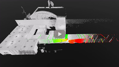
HERON - Change Detection Map


1. Use a point cloud or BIM model as a reference map.
2. Let HERON self-locate with respect to the reference.
3. Produce a survey aligned with the reference map.
4. Detect changes that occurred in the time.
5. Automatically get the change detection map for further editing.

CLOUD SHARING

Mobile mapping is dramatically speeding up the process of capturing 3D and image data. This should be matched by the speed of project delivery and online procedures.


To increase Site to Sight of data efficiency, GEXCEL customers can now link up with 3DUserNet to get a special free annual subscription to the VISION platform with a direct workflow from Reconstructor to 3DUserNetVISION. This will enable users to deliver more efficiently for their customers – with the opportunity to upgrade to a full subscription at a substantial discount at any time.

For additional information: sales@gexcel.it


12 Oct 2020

thumbnail

PRESS RELEASE — Gexcel presents HERON® MS Twin

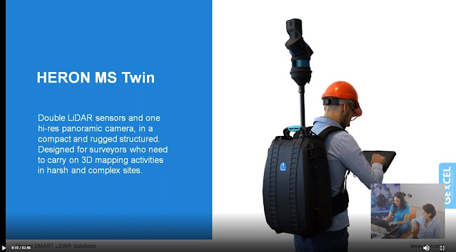
Brescia, Italy, October 7th, 2020_Gexcel is glad to present the new HERON® MS Twin: a double Lidar sensor portable mobile mapping system, equipped with a 5k RGB panoramic camera. Thanks to its advanced hardware+software technology, the users can benefit from a very high-level performance in terms of geometric robustness of 3D models.


Key points of usability:

  • Compact capture head easily mountable on a backpack or various supports like cars, bikes, quads, etc.
  • Light rugged backpack usable both for transportation and surveying.
  • Automatic and on-demand RGB data acquisition.
  • Loop closure and initialization procedure not required.
  • Automatic self-localization on a reference model, when available.
  • Annotation collection during the walk.
  • Usable in every light conditions.
  • Hands-free surveying.
  • Real-time display of panorama images, 3D point cloud, and trajectory on the rugged Control Unit.

Key points of data processing:

  • SLAM post-processing software (HERON® Desktop) included. The automatic advanced processing tools can be also personally set up by the user.
  • New trajectory quality assessment which improves the SLAM drift effects reduction (patented algorithm).
  • Innovative very dense point cloud rendering with multiple colour layers.

HERON MS Twin color layer

  • Static scans usable as trajectory constraints (patented algorithm).
  • Innovative panorama tool to directly export images and 3D data in ReCap® (with Realview® display) and in E57 to easily go to OrbitGT, Edgewise®, FARO® Scene and Scene Webshare Cloud.
  • New “splat rendering” and “eye dome lighting" rendering effect. Features and details are emphasized and well visible.
  • GoBlueprint free tool to share the survey results with final clients or colleagues included.

HERON GoBlueprint

  • Advanced 3D point cloud data analysis software included (Recontructor®).
  • Dedicated tools to navigate 3D models.
  • Real-time change detection.

Thanks to these advanced features, HERON® MS Twin is the perfect system for surveyors who works indoors, outdoors, in underground mines, multi-level buildings, tunnels, cultural heritage sites, forensic procedures, forests, urban areas, harsh and complex areas.

HERON® MS Twin can make the user able to obtain several outputs from collected data: volume computation, excavation progress monitoring, digital archive, construction progress monitoring, floor plans generation for asset management, logistic/traffic management, dilapidation monitoring, scan to BIM, contours and profiles, 3D virtual experience, real-time change detection, as-built generation, security and safety, and much more.

* * *

New HERON MS Twin Live Demo

- watch the webinar recording -

new HERON MS Twin - Webinar
New HERON MS Twin Live demo - Recording

10 Mar 2020

thumbnail

PRESS RELEASE — Gexcel announces RECONSTRUCTOR® 4.2

Brescia, Italy, February 27th, 2020_Gexcel is glad to announce the new release of Reconstructor® that introduces some very interesting improvements for mining, tunnelling, construction, and infrastructure applications thanks to new strategic workflows designed to easily guide customers to final deliverables from the surveying data.


Reconstructor® 4.2 makes a step forward into the processing of large datasets from various 3D sensors and in particular from Mobile Mapping Systems. Reconstructor® 4.2 increases the capability to manage data from tunnels, underground and open-pit mines 3D surveys, thanks to new and improved tools that help users get the result done by a smart process.

Following, a selection of some new key functions introduced in Reconstructor® 4.2:
  • Tunnels, underground and open-pit mines: easy extraction of sequential cross-sections along tunnels axis; measurement of areas and volumes along tunnels; creation of DEM (digital elevation models) starting from 3D point clouds; straight workflow to extract isolines and contours from open-pit mine models and DEMs.
  • Terrain models, buildings and infrastructures: orthophotos can now be used to quickly and efficiently create facades' depth maps. This function can be used also by final clients thanks to the new GoBlueprint free tool. Also, the procedure to extract, display, measure, and move to CAD profiles and cross-sections is now faster and more efficient.
  • Vegetation: colour mapping for point clouds classification and to support the vegetation removal process.
For additional information and demo, click here

26 Feb 2019

thumbnail

PRESS RELEASE — NEW Reconstructor® 4.0

26th February 2019, Italy — Gexcel today announced a new JRC 3D Reconstructor® release with revolutionary changes and improvements that are going to bring interesting and powerful features on the 3D LiDAR data processing software market. 

With the coming release, the well-known software manufactured by Gexcel will change its name in Reconstructor®, a revised brand for a new agile and easily usable application. This newest release 4.0 expands on the most popular software features, providing customers with even more opportunities to get more out of their dataset, save time and build stunning deliverables.

“Since the beginning, Reconstructor® has been a unique tool for a wide range of laser scanning users. This new release is a great step forward in terms of efficiency, usability, and brilliance”, said Matteo Sgrenzaroli, Gexcel’s R&D manager. “There’s a rich basket of new features in this new release, and we can’t wait to see what users will create with it”.


These are some of the key functions added or improved in Reconstructor® 4.0:

  • NEW SOFTWARE MODULARIZATION and LAYOUT to organize the processing tools and customize the software user interface: Reconstructor® 4.0 and its new add-ons are organized in a completely new user interface that provides simple and straightforward access to the software tools.
  • NEW RENDERING ENGINE for a new powerful way to display 3D modelsReconstructor® 4.0 upgrades the 3D visualization engine providing a completely new and more efficient rendering environment for clouds and meshes, unlocking a completely different experience of 3D object visualization. A strong improvement in using the PC graphics resources will let customers handle point clouds up to 200% larger than before.
  • FASTER and MORE EFFICIENT DATA IMPORT and PROCESSING: With Reconstructor® 4.0, the time required for scan importing and filtering is dramatically reduced, saving more than twice the time required by previous releases.
  • LineUp to automatically register CAD and BIM models: LineUp®, the popular and appreciated technology for automatic scans registration, is now fully embedded in Reconstructor® 4.0 main module. The well-known automatic target-less registration tool has been improved to support CAD/BIM and mesh models. 
  • X-RAY ORTHOPHOTOS for easy measuring and drawing: Reconstructor® 4.0 offers a completely new way to extract orthophotos and blueprints enhancing the relevant geometric features of a 3D scanned object. With the innovative GoBluprint free tool, it will be extremely easy to share X-Ray orthophotos among the users' community.

Press HERE to discover the entire changelog for Reconstructor 4.0 


DISCOVER. TRY. ENJOY

RECONSTRUCTOR® 4.0
 FREE DOWNLOAD

For more information or to receive a quotation, contact us: sales@gexcel.it

11 Dec 2018

thumbnail

PRESS RELEASE — Gexcel presents the new HERON® Indoor Mobile Mapping System

11th December 2018, Italy — Thanks to the new full HD 360° panoramic camera, HERON® has become a powerful tool for geospatial data mining: to digitally document, collect and geo-reference large dataset and information inside indoor environments has never been so easy, thanks to the perfect integration with OrbitGT packages too.

Gexcel - New HERON Indoor Mobile Mapping System


Gexcel is glad to introduce the market to the innovative benefits provided by the new HERON® family:
  • Thanks to the new high-res 360° panoramic camera, HERON® has become the best choice for facility management, geospatial applications, digital 3D documentation, digital twins for remote planning and project, revamping projects of industrial plants, etc.
  • With the GoBlueprint® free tool (fast point clouds 2D visualization), HERON® users can easily share with clients, already in the field and almost in real-time, the results of the HERON® fast 3D mapping.
  • Now, point clouds coming from drones and/or static scans, as GNSS known points, can become constraints information inside the workflow of the HERON® 3D SLAM data processing.

Gexcel - GoBlueprint free tool


The HERON® family is currently composed of HERON® AC-2 and HERON® MS-2 (rugged device for underground mines or difficult environments), both available in the Color configuration. The HERON® LITE model is the best solution for customers who want to join the HERON® family with an affordable investment.


1 Aug 2017

thumbnail

PRESS RELEASE — New JRC 3D Reconstructor® 3.3.1

1st August, 2017, Italy — We are glad to share with you the latest improvements of JRC 3D Reconstructor 3.3.1. In this release some small bugs fixed and new features for a more flexible and smart post-processing experience implemented!

JRC 3D Reconstructor can now automatically detect reference spheres (with registration or geo-referencing of single/multiple related scans) and also generate spherical 360° panorama images from RGB camera centered on a rotating 3D scanner head. See the full list of improvements


JRC 3D Reconstructor 3.3.1 what's new


DISCOVER . TRY . ENJOY

JRC 3D RECONSTRUCTOR 3.3.1


For more information or to receive a quotation, contact us: sales@gexcel.it