Search This Blog

Showing posts with label case studies. Show all posts

27 May 2021

thumbnail

HERON SUCCESS CASE — VOLUMES OF SCRAP METAL STOCKPILES

THE PRODUCTION PROCESS OPTIMIZATION IN A STEEL PLANT 

Feralpi Group – Lonato, Brescia (IT)

PDF versione italiana

PROJECT DESCRIPTION

KEYWORDS: Steel plants | Volumes computation | Stockpiles | Heron | 3D Mapping


HERON portable mobile mapping - stockpile volume computation - Feralpi Group

HERON MS TWIN-metal stockpile 3D mapping


Feralpi has set itself the goal of introducing advanced systems to monitor and verify the flows of raw materials and by-products of the steel mill, in order to optimize its production process.
Feralpi has chosen HERON technology because it fits their different needs. On one hand, the need to periodically obtain the volumes of the scrap stockpiles stored on a large area of the plant; on the other hand, the need for a high speed of scanning and results delivery, ensuring the required accuracy.
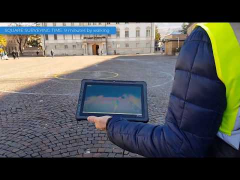
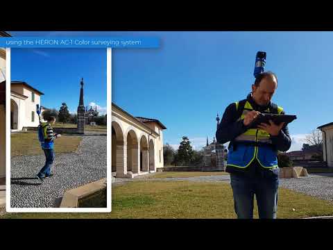
The project involves a monthly survey of the material stockpiles with HERON portable laser scanner technology.
During the 3D modelling phase, the stockpiles are isolated from the structural elements of the plant to define their volume.
The day after the measurement, a technical report with the measurements of the overall volumes is provided to Feralpi.
Thanks to this technological improvement, Feralpi is experimenting with a more efficient approach to the management of raw materials at low costs.


NEEDS AND GOALS
  • To monitor and verify the flows of raw materials and by-products of steelworks by using advanced systems.
  • To optimize the production process.


« Thanks to HERON technology we are able to map our material parks in a short time and with high precision. »


Gianpaolo Foglio |  
Head of Steelworks at Feralpi Siderurgica S.p.A.


HERON-Reconstructor scrap metal stockpile volume computation - Feralpi Group


HERON MAIN BENEFITS

  • Fast and simple mapping procedures easy to reproduce
  • Fast mapping of large stockpiles
  • No impact on daily production activities
  • Fast volumes computation
  • Centimetre level accuracy
  • Costs reduction
  • Production efficiency improvement
  • Usable for mapping different type of sites (steel plants as well as buildings)

              RESULTS

              • Stockpiles 3D modelling
              • Volumes computation

              TECHNICAL DETAILS

              • SURVEYING SYSTEM: HERON portable mapping system
              • SURVEYING TIME: about 1 h for 18.300 m2
              • PROCESSING SOFTWARE: HERON Desktop - Reconstructor
              • DATA PROCESSING TIME: half working day


              To carry out the work, Feralpi Group makes use of the HERON rental service with the operator, data processing and delivery of results.


              ABOUT

              The Feralpi Group is one of Europe's leading steel manufacturers. It offers innovative and sustainable answers to the steel supply chains thanks to a diversified and vertical business.

              12 Dec 2018

              thumbnail

              JRC 3D RECONSTRUCTOR SUCCESS CASE — EARTHQUAKE DEFORMATIONS CHECK

              RESTORATION AND CONSERVATION INTERVENTION Temple of Belén, Cusco (PERU)

              PDF versione italiana

              PROJECT DESCRIPTION

              KEYWORDS: Architectural | Conservation | JRC 3D Reconstructor | Laser scanner


              The church of Belén stands on a strongly seismic territory that from its origins has undermined the structure, rebuilt several times. After the damages caused by the earthquake of 1950, the internal consolidation of the vaults and domes was carried out, in order to avoid subsequent collapses, and only recently (for the first time!) a laser scanner survey was commissioned by the Ministry of Culture in Cusco to evaluate the actual structural conditions of the church and undertake restoration work. Thanks to this important technological step, it was immediately possible to notice some serious structural problems concerning the subsidence of the cupola. An aspect that would never have emerged with traditional measurement systems.


              Restauro sac_Templo de Belén-Cusco_JRC 3D Reconstructor_Survey activities and 3d point cloud model
              Fig.1_Survey activities and 3D point cloud model

              NEEDS AND GOALS
              • Measure, analyze and document the phenomena of the degradation of the church useful for the restoration project.
              • Get for the first time an accurate survey to obtain a full view of the building.

              « Working with highly technological tools allows great precision in a short time, which for the client translates into high quality at affordable prices. JRC 3D Reconstructor is an easy-to-use software: only one operator can do the whole job obtaining accuracy never seen before! »

              Wilfredo Torres | CEO at Restauro S.A.C.

              Restauro sac_Templo de Belén-Cusco_JRC 3D Reconstructor_Side elevation with high-res orthophoto
              Fig.2_Side elevation with high-res orthophotos
              Restauro sac_Templo de Belén-Cusco_JRC 3D Reconstructor_CAD drawings with high-res orthophoto
              Fig.3_CAD drawings with high-res orthophotos

              TECHNOLOGY BENEFITS
              • Rapidity of 2D and 3D data extraction.
              • Millimetre accuracy of the technical result.
              • Precision and accuracy of data.
              • Time savings in data processing and acquisition.

              RESULTS

              • Detailed report of vaults deformations
              • Plans, elevations, sections 
              • High-Res orthophotos 
              • Data precision and accuracy 

              TECHNICAL DETAILS 

              • SURVEYING SYSTEMS: Faro Focus3D 130x laser scanner
              • SURVEYED AREA: 3,145.50 sqm
              • SURVEYING TIME: 3 days
              • PROCESSING SOFTWARE: Reconstructor | AutoCAD
              • DATA PROCESSING TIME: 1 month

              Restauro sac_Templo de Belén-Cusco_JRC 3D Reconstructor_CAD redrawing on the high-res orthophoto
              Fig.4_CAD redrawing on the high-res orthophoto


              ABOUT

              RESTAURO S.A.C. is a Peruvian company that offers a wide range of services related to Cultural Heritage needs. Founded in October 2009, it offers solutions for management, conservation and restoration problems thanks to a national and international experience as well as a selected professional team and high-level technologies.


              6 Dec 2018

              thumbnail

              HERON SUCCESS CASE — CIVIL PROTECTION

              PLANNING THE SECURITY OF PUBLIC EVENTS Fair square, Trento (IT)

              PDF versione italiana

              PROJECT DESCRIPTION

              KEYWORDS: Civil protection | Security | Public event management | Heron | 3D Mapping 

              One of the main problems in planning a public event is the lack of updated data. Over time, a site is subject to multiple changes (sidewalks, green areas, maintenance or remediation, etc.) and not always the maps, available for civil protection, represent real metric data. All these issues were met in the present use case, where a tensile structure was planned in the main square of Trento.


              NEEDS AND GOALS
              • Check for any differences between the existing cadastral maps and the current state of the square, in order to detect the presence of new elements potentially obstructing the public security plans.
              • Provide easy and effective analysis of places dedicated to events/fairs, starting from real and updated data.

              « I’ve been amazed of the speediness of HERON in providing us with real data of the location we chose for the event! Without the HERON real data we would not have seen that this space was not suitable for the structures and the pool of people we had in mind. »

              Stefano Farina | Safety Consultant and Trainer


              Trento square data elaboration

              Thanks to a quick walk with HERON it was possible to generate an updated map of the square and proceed with the planning of the safety of the routes. It was possible to discover that the large trees (not marked in the old maps) were a serious obstacle to the management of the event. It was therefore decided to change locations, preventing a huge waste of money and work. (Read more about the Italian public event rules "DECRETO GABRIELLI")


                Public event planning


                HERON AC-1 MAIN BENEFITS
                • Rapid survey and analysis of (large) environments both external and internal.
                • Real-time generation of 3D and 2D maps with 2-3 cm accuracy. 
                • Quick and frequent update of 2D and 3D maps thanks to the automatic localization of the instrument. Survey easily managed by operators with minimal knowledge of surveying.

                RESULTS
                • Blueprint map of the square
                • CAD map with safety path scheme
                • 3D point cloud model of the square

                TECHNICAL DETAILS
                • SURVEYING SYSTEM: HERON AC-1 Color
                • SURVEYING TIME: 720 mt in 9 minutes by walking
                • PROCESSING SOFTWARE: HERON Desktop - JRC 3D Reconstructor
                • DATA PROCESSING TIME: 45 minutes


                ABOUT

                The Client required to Gexcel the rent of HERON with the operator for the surveying activities and the data processing delivery. For a privacy agreement, Gexcel is not allowed to show the Client’s name.

                5 Dec 2018

                thumbnail

                JRC 3D RECONSTRUCTOR SUCCESS CASE — NON-INVASIVE ARCHITECTURAL DIAGNOSIS

                ANALYSIS AND CAD REPORT OF AN ANCIENT STABLE Rustic Court “La Faggiola”, Piacenza (ITALY)

                PDF versione italiana

                PROJECT DESCRIPTION

                KEYWORDS: Architectural | Conservation | JRC 3D Reconstructor | Laser scanner


                Rustic Court “La Faggiola”, Piacenza (ITALY) - Picture of the building and CAD redrawing  and high resolution colored orthophotos - by Studio Tecnico Cottini - JRC 3D Reconstructor
                Fig.1_Picture of the building and CAD redrawing with high-resolution coloured orthophotos

                The “Faggiola” Rustic Court is an ancient private residence (now public) dating back to the early twentieth century. Having been neglected for a long time, the client decided to check its status by relying on 3D surveying technologies, before proceeding with redevelopment works and refurbishment and restoration interventions. During the days on the field, we worked with laser scanner instruments and it was possible to detect the geometry of the entire building: from the external areas to every single room, obtaining the highest precision necessary for the graphics redrawing. The material components of the building have been of great importance: building and finishing materials, signs left over from the passage of time, have contributed to a greater understanding of the building's real conditions. The methodology used, fast and non-invasive, is suitable for completing architectural diagnoses of buildings and defining the type of interventions to be carried out, be it demolition or restoration.


                NEEDS AND GOALS
                • A detailed survey of the external and internal environments of the building.
                • Graphics rendering of the exact geometry of the building (plans, sections, and elevations) and material components.
                • Future restoration and conservation interventions.

                Rustic Court “La Faggiola”, Piacenza (ITALY) - Colorful 3D model - point cloud (general view) - by Studio Tecnico Cottini - JRC 3D Reconstructor
                Fig.2_Colorful 3D model - point cloud (general view)

                Rustic Court “La Faggiola”, Piacenza (ITALY) - CAD redrawing with high resolution colored orthophotos - by Studio Tecnico Cottini - JRC 3D Reconstructor
                Fig.3_CAD redrawing with high-resolution coloured orthophotos

                « Thanks to the data collected during the laser scanner survey and the use of JRC 3D Reconstructor processing software, it was possible to obtain a thorough reading of the material components of the building, through the extraction of high-resolution orthophotos, following applied to the CAD drawings. »

                Elena Plebani | Architect at Studio Tecnico Cottini

                RESULTS
                • Detailed technical table with high-resolution orthophotos
                • 3D point cloud model
                • 2D plans and views with millimetric precision

                TECHNOLOGY BENEFITS
                • The precision of final results
                • Management of data coming from different laser scanners.
                • Quick and precise processing of data.

                TECHNICAL DETAILS
                • SURVEYING SYSTEM: Terrestrial Laser Scanner | Total Station
                • SURVEYED AREA: 700 m²
                • SURVEYING TIME: 2 days
                • PROCESSING SOFTWARE: JRC 3D Reconstructor
                • DATA PROCESSING TIME: 2 weeks

                « The merging between the processed point clouds and the traditional topographic polygon, inside JRC 3D Reconstructor, completes the survey in any aspect. »

                Marco Salvi | Engineer at Studio Tecnico Cottini

                Rustic Court “La Faggiola”, Piacenza (ITALY) - Colorful 3D model - point cloud (partial view) - by Studio Tecnico Cottini - JRC 3D Reconstructor
                Fig.4_Colorful 3D model - point cloud (partial view)


                ABOUT

                Studio tecnico ing.i. Adriano Cottini
                The Cottini engineering studio deals with topographic surveys, laser scanner surveys, data processing from point clouds, drafting of graphics drawings and planning for residential and civil construction works.


                9 Nov 2018

                thumbnail

                HERON SUCCESS CASE — MUSEUM DOCUMENTATION

                VIRTUAL REALITY FOR MUSEUM SERVICES ORGANIZING
                MarteS - Art museum Sorlini, Calvagese della Riviera (IT)

                PDF versione italiana

                PROJECT DESCRIPTION

                KEYWORDS: Virtual reality | Art | Museum | Heritage | Digitalization | HERON


                The "Luciano Sorlini Foundation" is located within the largest architectural complex of Calvagese della Riviera and, from March 31, 2018, is the headquarters of the MarteS. Sorlini Museum of Art: a private art gallery that exhibits to the public the works collected over time by the entrepreneur from Brescia Luciano Sorlini (1925-2015). Before the opening to the public, Stefano Lusardi, conservator of the new museum, and Giustina Irene, from DICATAM University of Brescia, commissioned a 3D survey of the building for museum services organizing.


                For this particular work, the Topotek company has chosen to exploit the HERON AC-1 Color technology. 3D mapping acquisitions were carried out following two paths: the first one walking along 1.390 meters in 22 minutes crossing the gardens and the open spaces inside the court, and the second one of 610 meters, extended from the gardens to the outside of the villa, by covering the whole block, including the city square and the war memorial monument. Using the HERON Desktop software, it was possible to obtain a point cloud in .ply format and an "x-ray plan". After that, the results were imported into JRC 3D Reconstructor and automatically aligned.


                In an hour only, the 3D movie of the detected building was generated. Thanks to the HERON technology, was quickly acquired a large number of elements, fundamental for future museum projects. We are therefore faced with the possibility of moving 3D data into video animations or exploiting them to create interactive activities for VR viewers.


                NEEDS AND GOALS
                • A fast survey of the ancient Sorlini palace to generate a 2D drawing of the main building surrounding
                • Realized a 3D movie for the MarteS museum inauguration
                • Using the acquired 3D data to the future plan of museum services organization

                HERON AC-1 MAIN BENEFITS
                • Innovation of the product
                • Speed in obtaining technical drawings
                • Intelligibility with third-party 2D and 3D resources

                RESULTS
                • 2D blueprint plans
                • Indoor and outdoor 3D flythrough video
                • 3D point cloud with trajectory and photographic information

                TECHNICAL DETAILS
                • SURVEYING SYSTEM: HERON AC-1 Color
                • SURVEYING AREA: 2.000 sqm
                • SURVEYING TIME: 29 minutes by walking
                • PROCESSING SOFTWARE: HERON Desktop and JRC 3D Reconstructor
                • DATA PROCESSING TIME: 45 minutes + 1 hour for the movie creation

                16 Oct 2018

                thumbnail

                HERON SUCCESS CASE — 3D MAPPING OF UNDERGROUND MINES

                3D SURVEYING OF UNDERGROUND FIELDS FOR GEOLOGICAL ANALYSIS Abandoned mines of Paglio (Dossena, BG), Italy

                PDF versione italiana

                PROJECT DESCRIPTION

                KEYWORDS: Mining | Underground | HERON | 3D Mapping


                HERON®MS-1 inside the Dossena underground site

                Dossena's mine survey activities

                NEEDS AND GOALS
                • Geometric acquisition of underground environments at various levels of depth in a disused mine.
                • Production of georeferenced data for subsequent assessments of geological stability of the site.

                Underground mines represent an important challenge for geometric surveying activities. The narrow spaces, sudden gradients, the presence of water, dust and humidity, the uneven paving and the impossibility to receive the GNSS signal often make it impossible to apply the traditional survey techniques. At Paglio's abandoned mines, thanks to the use of HERON system, it was possible to penetrate the entrails of the mines and measure the extent of underground environments, providing a mesh model of the entire structure.

                « The rugged backpack of HERON MS-1 made it possible to easily move around the different environments, even where the presence of water and dust could have hindered the success of the work »

                Stefano Cantoni | Surveyor, University of Brescia

                HERON Dossena mining analysis
                HERON point cloud aligned with a georeferenced static scan

                RESULTS

                • 3D point cloud model
                • 2D map (blueprint)
                • Surfaces model (mesh) of surveyed environments
                • Profiles and sections
                • Volumes and areas

                The carried out activities are part of the studies and works aimed at the recovery of the former fluorite mines of Paglio Pignolino in the Municipality of Dossena (BG) for fruition, tourism and scientific purposes. The described case saw the use of the HERON system in its rugged version called MS (Mining Survey), designed to operate effectively in aggressive environments such as deep mines. The data processing has produced 3 plants of the mine almost in real-time, thanks to the HERON Desktop software. The 3D point cloud generated by the instrument was subsequently transformed into a mesh model with the JRC 3D Reconstructor software.


                Dossena mine planimetric view
                Planimetric view of different deep mining levels

                The interventions are commissioned and coordinated by the Municipal Administration, with the support of the Dossena Mining Association, for the management of the site, and of the geological associated study of Spada di Ranica for the study and design activities, with the collaboration of the University of Brescia.


                HERON MS-1 MAIN BENEFITS
                • Quick mapping of internal environments, without the use of targets for merging 3D scans.
                • Rapid detection (acquisition time equals walking speed).
                • Sturdy equipment suitable for aggressive environments.
                • Possibility to georeference the surveyed model.
                • Real-time control of the surveying process through 3D visualization of the acquired data.

                TECHNICAL DETAILS
                • SURVEYING SYSTEM: HERON MS-1
                • SURVEYING TIME: 2 hours for a path of 1,255 m and for georeferencing activities (through detection of spheres previously georeferenced with the total station)
                • PROCESSING SOFTWARE: HERON Desktop and JRC 3D Reconstructor®
                • PROCESSING TIME: 8 hours

                13 Sept 2018

                thumbnail

                HERON SUCCESS CASE — STREET EVALUATION AND UNDERGROUND DETECTION


                MAPPING AND ANALYSIS OF UNDERGROUND TUNNEL AND UPPER STREETS Aposa underground river, Bologna (Italy)

                PDF versione italiana

                PROJECT DESCRIPTION

                KEYWORDS:  Street evaluation | Urban analysis | Mapping | HERON | Wearable 3D Laser Scanner | Underground city verification


                Gexcel, in collaboration with Topcon Italy, College of Surveyors di Bologna and Amici Delle Acque Association, carried out the 3D survey of the underground river Aposa. The ancient tunnels have been mapped and analyzed to verify the level of structural deterioration, dangerous for overlying squares and roads, and to plan possible conservation activities.


                HERON outdoor survey of the Aposa river
                Fig.1_HERON outdoor survey of the Aposa underground river
                Bologna underground tunnel entry
                Fig.2_The exit from the city underground tunnel


                NEEDS AND GOALS

                • Generate a 3D model of the underground city tunnels
                • Update the existing city map with 3D laser scanner information
                • Obtain a geo-referenced 3D survey
                • Analyze the geometry to prevent collapses or faults and historical monuments deterioration


                HERON survey of the Bologna underground tunnel
                Fig.3_The Aposa underground tunnels and the HERON surveying 


                HERON AC-1 technology has been used to detect approximately one kilometre of route distributed between streets, squares and underground tunnels, without the need for GPS systems. The duration of the survey corresponded to the time taken by the operator to walk. Some spherical targets were placed along the tunnel, noting down their coordinates directly on the HERON Control Unit. In this way, geo-localization could also be achieved. The many cavities along the tunnel were not a problem and the operator was able to survey even the narrowest of them.  (See Video)


                Bologna underground topographic surveying
                Fig.4_Topographic surveying of a portion of the Aposa tunnels


                The topographic survey was carried out, using 8 control stations and 40 reference points for a high geometric accuracy result. The Topcon GLS2000 static laser scanner survey was necessary for a very old and particularly damaged part of the tunnel. In this way, high-resolution data was obtained, useful for an accurate analysis of the actual state of the structure.


                Bologna 3D underground analysis
                Fig.5_Bologna underground tunnel and upper street analysis 

                Aposa underground tunnel cross section
                Fig.6_The Aposa Underground tunnel cross-section


                Combining the HERON global survey with high-resolution scans, it was possible to document a significant urban area, obtaining multilevel information and a complete 2D and 3D mapping.
                Here some of the HERON technology benefits:

                • Fast mapping of a large area in difficult surveying conditions
                • Fast and frequent update of site’s 3D models' thanks to the automatic geo-localization feature. Operators with basic knowledge in surveying and geo-localization can easily manage it. 
                • Easy integration with coloured point clouds from terrestrial laser scanners


                RESULTS

                • Detailed technical table
                • Plans, sections, elevations, high-resolution orthophotos and photo plans
                • 3D point cloud model
                • 3D model flythrough movies
                • Topcon terrestrial laser scanner and HERON mobile mapping system joint 3D model


                Aposa: Bologna underground 3D model
                Fig.7_The joint 3D model visualized in the JRC 3D Reconstructor software


                7 Aug 2018

                thumbnail

                JRC 3D RECONSTRUCTOR SUCCESS CASE — ARCHAEOLOGICAL MEASUREMENT

                CONSERVATION AND RESTORATION Tambomachay complex, Cusco (PERU)

                PDF versione italiana

                PROJECT DESCRIPTION

                KEYWORDS: Cultural Heritage | Archaeology | JRC 3D Reconstructor | LiDAR data

                Tambomachay, Peru - Orthophoto of the entire complex - by Restauro SAC - JRC 3D Reconstructor
                Fig1_Orthophoto of the masonry complex

                In 2017, the CDC Ministry of Peruvian culture commissioned to Restauro S.A.C. the surveying of some Inca historical sites. The Tambomachay is one of these: near to Cusco, this site consists of a series of aqueducts, canals, and waterfalls running through the terraced rocks. It is important to know that, till not long time ago, the measurement of these ancient walls was done by very rudimentary techniques: large sheets of millimetric paper were placed on the wall to manually trace the contours of every single stone and later manually redrawn in the CAD environment. As you can imagine, this workflow is incredibly time/money expensive as it requires months (years!) of work to get results always uncertain, because of drawing errors or missing details (ledge, cavity, pictures, etc.). This the reason that brought the company to operate with a laser scanner technology to face this important work. Thanks to this method it was possible to make a complete survey in less than one working day and extract rocks contour lines measurable with millimetric precision, thanks to the JRC 3D Reconstructor post-processing software.


                NEEDS AND GOALS
                • To measure, analyze and document the ancient masonry build by the Inca population.
                • To detect the exact position and verify the deterioration and/or structural failure over time.
                • To intervene with conservation works.

                  Tambomachay, Peru - Picture of the site and orthophoto of the masonry - by Restauro SAC - JRC 3D Reconstructor
                  Fig.2-3_Orthographic view and the picture of Tambomachay site

                  Tambomachay, Peru - High Res orthophoto of the stones - by Restauro SAC - JRC 3D Reconstructor
                  Fig.4_High Res orthophoto showing the detail of the stones

                  « The processing speediness and accuracy allowed us to generate 2D and 3D data with a precision impossible for the traditional surveying methods. Thanks to JRC 3D Reconstructor, we daily improve the quality and productivity of our job. »
                  Wilfredo Torres, Restauro S.A.C. | CEO

                  To complete the documentation project and illustrate the real artefact conditions, a CAD drawing with orthophotos was provided.

                  RESULTS
                  • Detailed technical table with high-resolution orthophotos
                  • 3D point cloud model
                  • 2D plans and views with millimetric precision

                  TECHNOLOGY BENEFITS
                  • The speediness of 2D and 3D data extraction
                  • The millimetric precision of technical results

                  TECHNICAL DETAILS
                  • SURVEYING SYSTEM: Faro Focus3D 130x
                  • SURVEYING AREA: 2.982 m²
                  • SURVEYING TIME: 4 hours
                  • PROCESSING SOFTWARE: JRC 3D Reconstructor
                  • PROCESSING TIME: 6 hours

                    Tambomachay, Peru - CAD plans with CAD plans with photographic view - by Restauro SAC - JRC 3D Reconstructor
                    Fig.5_Plan of the scanned site


                    ABOUT

                    RESTAURO S.A.C. is a Peruvian company that offers a wide range of services related to Cultural Heritage needs. Founded in October 2009, it offers solutions for management, conservation and restoration problems thanks to a national and international experience as well as a selected professional team and high-level technologies.