Search This Blog

Showing posts with label solutions. Show all posts

12 Oct 2020

thumbnail

PRESS RELEASE — Gexcel presents HERON® MS Twin

Brescia, Italy, October 7th, 2020_Gexcel is glad to present the new HERON® MS Twin: a double Lidar sensor portable mobile mapping system, equipped with a 5k RGB panoramic camera. Thanks to its advanced hardware+software technology, the users can benefit from a very high-level performance in terms of geometric robustness of 3D models.


Key points of usability:

  • Compact capture head easily mountable on a backpack or various supports like cars, bikes, quads, etc.
  • Light rugged backpack usable both for transportation and surveying.
  • Automatic and on-demand RGB data acquisition.
  • Loop closure and initialization procedure not required.
  • Automatic self-localization on a reference model, when available.
  • Annotation collection during the walk.
  • Usable in every light conditions.
  • Hands-free surveying.
  • Real-time display of panorama images, 3D point cloud, and trajectory on the rugged Control Unit.

Key points of data processing:

  • SLAM post-processing software (HERON® Desktop) included. The automatic advanced processing tools can be also personally set up by the user.
  • New trajectory quality assessment which improves the SLAM drift effects reduction (patented algorithm).
  • Innovative very dense point cloud rendering with multiple colour layers.

HERON MS Twin color layer

  • Static scans usable as trajectory constraints (patented algorithm).
  • Innovative panorama tool to directly export images and 3D data in ReCap® (with Realview® display) and in E57 to easily go to OrbitGT, Edgewise®, FARO® Scene and Scene Webshare Cloud.
  • New “splat rendering” and “eye dome lighting" rendering effect. Features and details are emphasized and well visible.
  • GoBlueprint free tool to share the survey results with final clients or colleagues included.

HERON GoBlueprint

  • Advanced 3D point cloud data analysis software included (Recontructor®).
  • Dedicated tools to navigate 3D models.
  • Real-time change detection.

Thanks to these advanced features, HERON® MS Twin is the perfect system for surveyors who works indoors, outdoors, in underground mines, multi-level buildings, tunnels, cultural heritage sites, forensic procedures, forests, urban areas, harsh and complex areas.

HERON® MS Twin can make the user able to obtain several outputs from collected data: volume computation, excavation progress monitoring, digital archive, construction progress monitoring, floor plans generation for asset management, logistic/traffic management, dilapidation monitoring, scan to BIM, contours and profiles, 3D virtual experience, real-time change detection, as-built generation, security and safety, and much more.

* * *

New HERON MS Twin Live Demo

- watch the webinar recording -
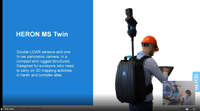
new HERON MS Twin - Webinar
New HERON MS Twin Live demo - Recording

6 Oct 2020

thumbnail

EVENT — The Gexcel program for INTERGEO DIGITAL 2020


Gexcel is ready for the new DIGITAL INTERGEO adventure, and you?

Don't miss the opportunities to better know the Gexcel's products during these days. Join one of our live webinars:

new HERON MS Twin Live demo
Discover the innovative and outstanding Gexcel portable mobile mapping system

OPMMS Open Pit Mine Monitoring System
The powerful system to monitor mines' sites automatically and remotely

RECONSTRUCTOR Point Cloud processing software
Laser scanner+Drone+Thermo camera: a restoration project in Peru

3 Jun 2019

thumbnail

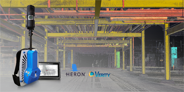
PRESS RELEASE — HERON®-Verity Integration Introduces Real-Time 3D Mobile Mapping and Construction Verification


HERON - Verity integration


The collaboration between HERON, the latest wearable mobile scanners from Gexcel and Verity construction verification software from ClearEdge3D, significantly advances scan-to-BIM workflows with streamlined data collection and construction QA/QC

Manassas, VA – May 29, 2019 – ClearEdge3D, makers of EdgeWise, Verity, and Rithm for Navisworks software, is pleased to announce a collaboration with Gexcel, makers of HERON® wearable scanners, that was unveiled at the SPAR 3D & AEC NEXT conferences last week in Anaheim, CA. 
The two companies have joined forces to make it even quicker and easier for AEC professionals to conveniently gather as-built data with Gexcel’s HERON wearable laser scanners—and to compare that data against design/fabrication models using ClearEdge3D’s Verity software, allowing 100% verification of installed work in real-time.
"The partnership between ClearEdge3D and Gexcel brings together two globally recognized AEC tech leaders in the 3D world that are committed to making scan-to-BIM workflows more efficient with truly cutting-edge technologies," - Matteo Sgrenzaroli, Gexcel R&D Manager 
“It’s not just a commercial agreement, but a demonstration of our commitment to providing outstanding solutions to our customers and the AEC industry." - Giorgio Vassena, Gexcel CEO
“The HERON scanner is a state-of-the-art 3D mobile scanner powered with cutting edge Simultaneous, Localization And Mapping (SLAM) technology. It features a host of proprietary algorithms to minimize drift and maximize accuracy and speed. We are excited to add it to our growing hardware portfolio.” - Kelly Cone, VP of AEC Industry Strategy at ClearEdge3D. 
This forward-thinking partnership makes it even easier and more convenient for users to find construction mistakes before they become expensive problems. Using real-time visualization of survey results, users can promptly identify out-of-tolerance or inaccurately constructed work. For companies interested in learning more about this collaboration, please contact us at: sales@gexcel.it for more information. 


About ClearEdge3D 
ClearEdge3D is a global technology leader in the Architectural/Engineering/Construction (AEC) industry, offering advanced software solutions that help firms model existing conditions and verify that recently completed work has been constructed correctly. The company’s EdgeWise software dramatically speeds labor-intensive 3D modeling workflows by utilizing advanced automated feature extraction and assistive modeling technology. Its Verity construction verification software compares point cloud data of recently completed work against a design or fabrication model, flagging any out-of-tolerance or poorly installed elements. For more information, please visit http://www.clearedge3d.com. 

About Gexcel 
Gexcel started in 2007 with the mission to turn the latest scientific achievements in the field of geomatics into hi-tech products and services for wide areas of application. Gexcel is a worldwide well-known company capable to transform its know-how in advanced 3D surveying technologies, innovative and productive software and instruments. Gexcel has a rich history spanning more than 10 years of proven fully featured LiDAR and imagery analysis software compatible with all the lidar sensors of the main laser scanner manufacturers. Gexcel is currently present on the market with innovative surveying instruments and it is involved, with several partners, in various projects for the development of innovative solutions based on laser scanner, SLAM and digital photogrammetry.   

8 Apr 2019

thumbnail

EVOCATION European project: Fellows recruitment


evocation european project


Formare la prossima generazione di innovatori, creativi ed imprenditori del 3D, per affrontare le sfide attuali future nei campi dell'acquisizione di geometrie scalabili e ad alta fedeltà, estrazione di strutture semantiche, elaborazione, visualizzazione e fabbricazione 3D per applicazioni professionali e di consumo. 

Questi sono gli obbiettivi del progetto europeo "EVOCATION-Advanced Visual and Geometric Computing for 3D Capture, Display, and Fabrication" che vede Gexcel partner insieme a enti di ricerca e Università che rappresentano l’eccellenza europea nella gestione di dati tridimensionali. Finanziato dalla Commissione Europea (call Horizon 2020 sulle reti di formazione europee Marie Skłodowska-Curie), vede la partecipazione oltre che di Gexcel dell'Università di Rostock, che coordinerà il progetto dal CNR-ISTI di Pisa, dal Fraunhofer-Institut für Graphische Datenverarbeitung IGD di Darmstadt, dall’Università di Zurigo, dall’Università Tecnica di Vienna, dal Dipartimento CRS4 di Sardegna Ricerche e dall’azienda ungherese Holografika. 

Il progetto, iniziato il 1 ottobre 2018 per la durata di 48 mesi, creerà un collegio di dottorato di primo piano a livello europeo. I dottorandi saranno associati ai partner del progetto e da una lunga lista di istituti che si sono resi disponibili ad ospitare per definiti periodi di tempo i dottorandi stessi. Tra questi enti e aziende sono presenti il Museo Archeologico di Cagliari, le Università di Cagliari e Pisa e l'impresa NVIDIA. 

Il ruolo di Gexcel nel progetto è di affiancare e formare il candidato nel programma di dottorato di ricerca di 36 mesi coordinato tra otto partner accademici e industriali, nello specifico il candidato sarà coinvolto nello studio e nello sviluppo di una pipeline di acquisizione e ricostruzione (strumenti di mappatura mobile e software di elaborazione), focalizzata sulla ricostruzione di geometrie interne 3D e per estrarre informazioni funzionali dalla realtà acquisita. Il progetto EVOCATION si inserisce nelle attività di un gruppo che è stato finora partner maggiore in 14 progetti UE e 4 USA nel periodo 1996-2018. 

Il reclutamento per i ESR borsisti è iniziato. 

Visita la pagina EVOCATION Recruitment per maggiori informazioni sulle pozizioni aperte. 


--------------


Gexcel is the technical partner and contributor of the European project "EVOCATION-Advanced Visual and Geometric Computing for 3D Capture, Display, and Fabrication" financed by the European Union’s (EU) Horizon 2020 research and innovation program under Marie Skłodowska-Curie. The Rostock University (Germany) coordinates the project supported by public and private bodies including CNR-ISTI, Fraunhofer, Zurich University, Vienna Technical University, CRS4 and Holografika. Third parties collaborations face the Archeological Museum of Cagliari, Cagliari University, Pisa University and NVIDIA enterprise.


The EVOCATION network of public and private entities is naturally multidisciplinary and multi-institutional will train the next generation of creative, entrepreneurial and innovative experts who will be equipped with the necessary skills and competencies to face current and future major challenges in scalable and high-fidelity shape and appearance acquisition, extraction of structure and semantic information, processing, visualization, 3D display and 3D fabrication in professional and consumer applications.The project has started on October 1, 2018, will continue for 48 months, to create a European foreground fellows collegium.


The Gexcel role is to support and train the candidate in the 36 months research doctorate program. The candidate will be involved in studying and developing an acquisition and reconstruction pipeline (mobile mapping instruments and processing software), focused on reconstruct 3D indoor geometries and to extract functional information from captured reality. The ESR initially will carry out the research of reconstruction on different inputs separately (3D data and image), then will explore data fusion techniques to improve structure recovery.


Recruitment for 14 ESR fellowships has started.

Visit the EVOCATION Recruitment Page for more information about available jobs.
Learn more about the EVOCATION project

11 Dec 2018

thumbnail

PRESS RELEASE — Gexcel presents the new HERON® Indoor Mobile Mapping System

11th December 2018, Italy — Thanks to the new full HD 360° panoramic camera, HERON® has become a powerful tool for geospatial data mining: to digitally document, collect and geo-reference large dataset and information inside indoor environments has never been so easy, thanks to the perfect integration with OrbitGT packages too.

Gexcel - New HERON Indoor Mobile Mapping System


Gexcel is glad to introduce the market to the innovative benefits provided by the new HERON® family:
  • Thanks to the new high-res 360° panoramic camera, HERON® has become the best choice for facility management, geospatial applications, digital 3D documentation, digital twins for remote planning and project, revamping projects of industrial plants, etc.
  • With the GoBlueprint® free tool (fast point clouds 2D visualization), HERON® users can easily share with clients, already in the field and almost in real-time, the results of the HERON® fast 3D mapping.
  • Now, point clouds coming from drones and/or static scans, as GNSS known points, can become constraints information inside the workflow of the HERON® 3D SLAM data processing.

Gexcel - GoBlueprint free tool


The HERON® family is currently composed of HERON® AC-2 and HERON® MS-2 (rugged device for underground mines or difficult environments), both available in the Color configuration. The HERON® LITE model is the best solution for customers who want to join the HERON® family with an affordable investment.


13 Sept 2018

thumbnail

HERON SUCCESS CASE — STREET EVALUATION AND UNDERGROUND DETECTION


MAPPING AND ANALYSIS OF UNDERGROUND TUNNEL AND UPPER STREETS Aposa underground river, Bologna (Italy)

PDF versione italiana

PROJECT DESCRIPTION

KEYWORDS:  Street evaluation | Urban analysis | Mapping | HERON | Wearable 3D Laser Scanner | Underground city verification


Gexcel, in collaboration with Topcon Italy, College of Surveyors di Bologna and Amici Delle Acque Association, carried out the 3D survey of the underground river Aposa. The ancient tunnels have been mapped and analyzed to verify the level of structural deterioration, dangerous for overlying squares and roads, and to plan possible conservation activities.


HERON outdoor survey of the Aposa river
Fig.1_HERON outdoor survey of the Aposa underground river
Bologna underground tunnel entry
Fig.2_The exit from the city underground tunnel


NEEDS AND GOALS

  • Generate a 3D model of the underground city tunnels
  • Update the existing city map with 3D laser scanner information
  • Obtain a geo-referenced 3D survey
  • Analyze the geometry to prevent collapses or faults and historical monuments deterioration


HERON survey of the Bologna underground tunnel
Fig.3_The Aposa underground tunnels and the HERON surveying 


HERON AC-1 technology has been used to detect approximately one kilometre of route distributed between streets, squares and underground tunnels, without the need for GPS systems. The duration of the survey corresponded to the time taken by the operator to walk. Some spherical targets were placed along the tunnel, noting down their coordinates directly on the HERON Control Unit. In this way, geo-localization could also be achieved. The many cavities along the tunnel were not a problem and the operator was able to survey even the narrowest of them.  (See Video)


Bologna underground topographic surveying
Fig.4_Topographic surveying of a portion of the Aposa tunnels


The topographic survey was carried out, using 8 control stations and 40 reference points for a high geometric accuracy result. The Topcon GLS2000 static laser scanner survey was necessary for a very old and particularly damaged part of the tunnel. In this way, high-resolution data was obtained, useful for an accurate analysis of the actual state of the structure.


Bologna 3D underground analysis
Fig.5_Bologna underground tunnel and upper street analysis 

Aposa underground tunnel cross section
Fig.6_The Aposa Underground tunnel cross-section


Combining the HERON global survey with high-resolution scans, it was possible to document a significant urban area, obtaining multilevel information and a complete 2D and 3D mapping.
Here some of the HERON technology benefits:

  • Fast mapping of a large area in difficult surveying conditions
  • Fast and frequent update of site’s 3D models' thanks to the automatic geo-localization feature. Operators with basic knowledge in surveying and geo-localization can easily manage it. 
  • Easy integration with coloured point clouds from terrestrial laser scanners


RESULTS

  • Detailed technical table
  • Plans, sections, elevations, high-resolution orthophotos and photo plans
  • 3D point cloud model
  • 3D model flythrough movies
  • Topcon terrestrial laser scanner and HERON mobile mapping system joint 3D model


Aposa: Bologna underground 3D model
Fig.7_The joint 3D model visualized in the JRC 3D Reconstructor software


17 May 2018

thumbnail

EVENT — Gexcel and HERON at GEO Business Show 2018

HERON® AC-1, the innovative Wearable Mobile Mapping System from Gexcel, is having a significant success worldwide on innovative BIM-check projects. Several customers are using the HERON® change detection feature to highlight differences between the reality and the BIM model: everything in real time.

Real-time and effective scan to BIM quality check services on huge sites, such as airports, industrial plants, and construction yards are now possible!


HERON® can survey complex environments without any external positioning system and is capable to highlight in real-time possible geometrical changes between different surveying sessions. Moreover, HERON® works as a localization system using either a former survey or a CAD model as reference frame.

Thanks to these unique features, HERON® has been adopted by international institutions and large companies involved in the nuclear power plant and advanced industrial projects.


>> Visit Us on Stand L15 at GEO Business (22-23 May, London) <<


19 Apr 2018

thumbnail

ELISIR project: eco-seismic building regeneration 4.0

Gexcel will provide its own technologies in 3D mapping, fast 3D digitalization, and BIM model update within the ELISIR project. These technologies are essential to drastically reduce costs and times of surveying activities and to assess in real-time the as-built conditions of a building.

ELISIR stands for Energy, Life Styled & Seismic Innovation for Regenerated Buildings and it aims at exploiting the potential of digitization in order to create a very personalized product-service to be offered on the market of the existing building heritage focused on seismic improvement and energy efficiency in a "smart living" way, developing a real "Built in Italy". The research project has been launched last November with a research call funded by the Lombardy Region and will end in May 2019.

gexcel-heron-elisir-progetto

Gexcel participates in the project, along with other important partners, using the HERON technology for the rapid survey of buildings, for the as-built data acquisition in the form of a point cloud, and will further develop the product adding the possibility of collecting camera data. Schneider will contribute by developing appropriate sensors for energy analysis, a platform for collecting, storing and processing data and validating them. Valsir will undertake the development of hydraulic connections leveraged by sensors, to monitor all the water consumption of the various users. H&D will craft appropriate financial products to provide "the business model and a brand capable of spreading and introducing innovation in the supply chain" with possible "consequences on foreign markets that will be investigated together with the partners involved". Delta Phoenix will fine-tune the energy seismic plaster. The development of smart windows will be taken care by Italserramenti, which will experiment products with a high degree of automation and intelligence, able to adapt to users' needs and independently manage environmental comfort.

The concept of the project was born at the DICATAM headquarters in the University of Brescia, on the initiative of Angelo Ciribini, one of the leading experts in Building Information Modeling (BIM) and digitization in construction. The second university involved is the Milan Polytechnic, with the Abc department - Architecture, Engineering and the built environment, and in particular with the operating units "Building envelope engineering group" and "Sustainable building process management group". Find more...

2 May 2017

thumbnail

EVENT — GEXCEL HERON is landing to GEO BUSINESS 2017


May, 2017, Brescia (Italy) — Are you coming to GEO BUSINESS SHOW in London and are you curious to see the new Gexcel HERON® system at work? Join the Gexcel's community!

Come to the Gexcel's Booth K14 and look at the HERON® mobile surveying system with its powerful and unique algorithm that makes the real time acquisition and the 3D model creation extremely smart and efficient!


...and don't miss the dedicated workshop!

WORKSHOP TUESDAY 23rd 16.15
Giorgia Rossi,Gexcel
HERON® THE WEARABLE MOBILE SURVEYING SYSTEM
Indoor or outdoor applications, walking or driving configuration able to provide 3D real time mapping, real time localization, change detection analysis and a powerful software brain to adjust and optimize scans. Access the Geo Business Agenda


For more information and appointments
please contact:

Giorgia Rossi arch.

International Sales Manager | Gexcel Srl
E. sales@gexcel.it
P. +39 030 65 95 001


Subscribe the Gexcel's newsletter and follow us on our channels:

[ youtube ]  [ twitter ]  [ facebook ]  [ linkedin ]


About Gexcel
Gexcel Srl has a rich history spanning more than 10 years of proven fully featured lidar and imagery analysis software packages as JRC 3D Reconstructor®, PointR3 and PixR3. Well-suited to all terrestrial, mobile and airborne scanners, Gexcel solutions are compatible and provided from all the main laser scanner manufacturers as DotProduct, Faro, Teledyne-Optech, Riegl, Stonex, Topcon, Trimble, Velodyne and Z+F. Gexcel Srl was established in 2007 from the academic know-how of the University of Brescia and the applied research achievements of the European Commission Joint Research Centre (JRC), located in Ispra (Italy).

13 Apr 2017

thumbnail

EVENT — HERON and Focus3D integration at the FARO 3D Conference 2017

April, 2017, Brescia (Italy) — Are you a FARO user and are you interested in learning more about the smart integration between your Focus3D scans and Gexcel HERON® 3D models?


Come to the FARO 3D Conference on April, 27th-28th (Germany): Gexcel will present this great innovation by showing a dedicated presentation focused on a real case where this technology has been used to speed up the surveying activities and furnish a complete final project. 

>> Register now <<  Come to the Conference and discover all the latest state of the art in reality capture, to exchange in technical meetings through real user examples and to discuss with experts.

Don't miss the Gexcel Presentation, on Thu, 27th at 9.45 amto see how easily HERON® can make your Focus3D laser scanner surveys more competitive and efficient in a very simple way! Access the complete Conference Agenda.


For more information and appointments
please contact:

Giorgia Rossi arch.
International Sales Manager | Gexcel Srl
E. sales@gexcel.it
P. +39 030 65 95 001


Subscribe the Gexcel's newsletter and follow us on our channels:
[ youtube ]  [ twitter ]  [ facebook ]  [ linkedin ]


About Gexcel
Gexcel Srl has a rich history spanning more than 10 years of proven fully featured lidar and imagery analysis software packages as JRC 3D Reconstructor®, PointR3 and PixR3. Well-suited to all terrestrial, mobile and airborne scanners, Gexcel solutions are compatible and provided from all the main laser scanner manufacturers as DotProduct, Faro, Teledyne-Optech, Riegl, Stonex, Topcon, Trimble and Z+F. Gexcel Srl was established in 2007 from the academic know-how of the University of Brescia and the applied research achievements of the European Commission Joint Research Centre (JRC), located in Ispra (Italy).

26 Oct 2016

thumbnail

PRESS RELEASE — HERON® The new real time mapping and tracking wearable system

October 26th, 2017, Brescia (Italy) — Great success at INTERGEO (Hamburg, Germany) for HERON®: the innovative indoor/outdoor real time mobile mapping and tracking wearable system, (composed by hardware and software), developed by Gexcel and European Commission Joint Research Centre.


HERON® is capable to support real time 3D measurements both in industrial plants and underground mining applications. HERON® does not use GNSS or precise IMU sensors, but just a clever and advanced algorithm.

Real time mapping, automatic localization, real time change detection system. This absolute innovative approach to manage the real time mapping and tracking indoor projects is opening new possibilities for industrial/nuclear plants surveying and tracking, underground mining, forest mapping.

Follow Gexcel on www.gexcel.it/en/heron-overview to find more on HERON® and its successfully applications.


About Gexcel
Gexcel Srl has a rich history spanning more than 10 years of proven fully featured lidar and imagery analysis software packages as JRC 3D Reconstructor®, PointR3 and PixR3. Well-suited to all terrestrial, mobile and airborne scanners, Gexcel solutions are compatible and provided from all the main laser scanner manufacturers as DotProduct, Faro, Teledyne-Optech, Riegl, Stonex, Topcon, Trimble and Z+F. Gexcel Srl was established in 2007 from the academic know-how of the University of Brescia and the applied research achievements of the European Commission Joint Research Centre (JRC), located in Ispra (Italy).

For more information please contact:
Giorgia Rossi arch. 
International Sales Manager | Gexcel Srl
Phone: +39 030 65 95 001

--------------

Published on:

- http://www.geoconnexion.com/news/heron-the-new-real-time-mapping-and-tracking-wearable-system


1 Jun 2016

thumbnail

PRESS RELEASE — Gexcel at SPAR Japan 2016

June 1st, 2016, Tokyo (Japan) — On Wednesday 1st, prof. Yoshiki Hori, Professor of History of Architecture and City Planning in Europe, from the Department of Architecture and Urban Design of Faculty of Human-Environment Studies of the Kyushu University (Japan), will present at SPAR Japan 2016 his research activities in 3D laser scanning surveying of international archeological sites.

At the same conference Mr. Muramatsu Kiyoshishin, Gexcel Japan technical manager, will chair a workshop focused on the use of the main Gexcel software for laser scanning, JRC 3D Reconstructor®.


The workshop will also introduce
- the new BIM&Industrial Plant Suite® (www.gexcel.it/en/software/suite)
- the new compatibility between DotProduct® data and JRC 3D Reconstructor® (www.gexcel.it/en/dot-product)


«JRC 3D Reconstructor® has been specifically designed to align or register many datasets and large volumes of point cloud data automatically. I can say that the point clouds processing engine of JRC 3D Reconstructor® can be used to improve the performance of the whole laser scanning data processing, providing a familiar software environment and meeting the needs of laser scanning data elaboration»

These are the considerations about JRC 3D Reconstructor® given to Gexcel Japan by Prof. Yoshiki Hori who has a long experience on the use of laser scanning for the documentation of ancient archeological sites around the world and, in particular, in Roman Archeological sites as Pompei and Ostia Antica in Italy.


Prof. Hori underlines that
«Many dense and extensive datasets of point clouds, resulting in many gigabyte of data, usually require large amount of RAM and a high performance graphics cards, but the crucial stage remain the process known as cloud alignment or registration, which is done using targets, such as spheres or checker boards. As that process is inevitable in terrestrial laser scanning, we have to spend much time and effort to align or register datasets increasing their size during the post-survey process».
Thanks to JRC 3D Reconstructor® now the data processing is faster than ever, in fact
«In my laboratory a few under or graduate students used to captured more than 30 datasets per day and the pre-registration process could not be completed until the next morning. Actually they do not work more so hard with the software but just running the pre-registration command. JRC 3D Reconstructor® has become essential for the process of integration and management of many point clouds in different formats produced by Leica, Faro, Teledyne-Optech, etc.»


==========

At SPAR Japan, Gexcel will also announce that, starting from 2016, has become the official representative of the SITECO RoadScanner  MOBILE MAPPING SYSTEM  in Asia Pacific. Configurable with various sensors and Inertial Navigation Systems, RoadScanner4 and RoadScanner Compact represent the right flexible choice for 3D mobile laser scanner surveying.

Find more information about the system solutions


About Gexcel
Gexcel Srl has a rich history spanning more than 10 years of proven fully featured lidar and imagery analysis software packages with the JRC 3D Reconstructor®, completely compatible with all terrestrial, mobile and airborne scanners from manufacturers such as Faro, Teledyne-Optech, Riegl, Stonex, Topcon, Trimble and Z+F. Gexcel Srl was established in 2007 from the academic know-how of the University of Brescia and the applied research achievements of the European Joint Research Centre (JRC), located in Ispra (Italy). Gexcel Srl is proud to support all major standard formats such as the ASTM E57 and LAS.

For more information please contact:arch. Giorgia Rossi
International Sales Manager | Gexcel Srl
Phone: +39 030 65 95 001

--------------