3D SURVEYING OF UNDERGROUND FIELDS FOR GEOLOGICAL ANALYSIS Abandoned mines of Paglio (Dossena, BG), Italy
PDF versione italiana
KEYWORDS: Mining | Underground | HERON | 3D Mapping
 |
 |
| Dossena's mine survey activities |
NEEDS AND GOALS
- Geometric acquisition of underground environments at various levels of depth in a disused mine.
- Production of georeferenced data for subsequent assessments of geological stability of the site.
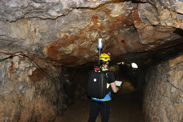
Underground mines represent an important challenge for geometric surveying activities. The narrow spaces, sudden gradients, the presence of water, dust and humidity, the uneven paving and the impossibility to receive the GNSS signal often make it impossible to apply the traditional survey techniques. At Paglio's abandoned mines, thanks to the use of HERON system, it was possible to penetrate the entrails of the mines and measure the extent of underground environments, providing a mesh model of the entire structure.
« The rugged backpack of HERON MS-1 made it possible to easily move around the different environments, even where the presence of water and dust could have hindered the success of the work »
Stefano Cantoni | Surveyor, University of Brescia
 |
| HERON point cloud aligned with a georeferenced static scan |
RESULTS
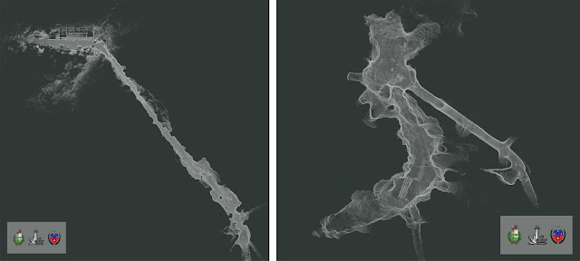
The carried out activities are part of the studies and works aimed at the recovery of the former fluorite mines of Paglio Pignolino in the Municipality of Dossena (BG) for fruition, tourism and scientific purposes. The described case saw the use of the HERON system in its rugged version called MS (Mining Survey), designed to operate effectively in aggressive environments such as deep mines. The data processing has produced 3 plants of the mine almost in real-time, thanks to the HERON Desktop software. The 3D point cloud generated by the instrument was subsequently transformed into a mesh model with the JRC 3D Reconstructor software.
The interventions are commissioned and coordinated by the Municipal Administration, with the support of the Dossena Mining Association, for the management of the site, and of the geological associated study of Spada di Ranica for the study and design activities, with the collaboration of the University of Brescia.
- 3D point cloud model
- 2D map (blueprint)
- Surfaces model (mesh) of surveyed environments
- Profiles and sections
- Volumes and areas
The carried out activities are part of the studies and works aimed at the recovery of the former fluorite mines of Paglio Pignolino in the Municipality of Dossena (BG) for fruition, tourism and scientific purposes. The described case saw the use of the HERON system in its rugged version called MS (Mining Survey), designed to operate effectively in aggressive environments such as deep mines. The data processing has produced 3 plants of the mine almost in real-time, thanks to the HERON Desktop software. The 3D point cloud generated by the instrument was subsequently transformed into a mesh model with the JRC 3D Reconstructor software.
 |
| Planimetric view of different deep mining levels |
The interventions are commissioned and coordinated by the Municipal Administration, with the support of the Dossena Mining Association, for the management of the site, and of the geological associated study of Spada di Ranica for the study and design activities, with the collaboration of the University of Brescia.
HERON MS-1 MAIN BENEFITS
- Quick mapping of internal environments, without the use of targets for merging 3D scans.
- Rapid detection (acquisition time equals walking speed).
- Sturdy equipment suitable for aggressive environments.
- Possibility to georeference the surveyed model.
- Real-time control of the surveying process through 3D visualization of the acquired data.
TECHNICAL DETAILS
- SURVEYING SYSTEM: HERON MS-1
- SURVEYING TIME: 2 hours for a path of 1,255 m and for georeferencing activities (through detection of spheres previously georeferenced with the total station)
- PROCESSING SOFTWARE: HERON Desktop and JRC 3D Reconstructor®
- PROCESSING TIME: 8 hours
12:45:00 pm
Tags :
case studies
,
heron
,
mining
Subscribe by Email
Follow Updates Articles from This Blog via Email


No Comments